Silla geodata
Silla (Valencia) is a seat of a third-order administrative division; located in Spain in Europe/Madrid (GMT+2) time zone. With population of 18,979 people, there are 498 cities with bigger population in this country. Compared to other cities in Spain, 78.2% of cities are located further ↑North; 83% of cities are located further ←West and 97.9% of cities have higher elevation than Silla. Note1


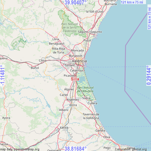
Silla GPS coordinates[2]
39° 21' 45.252" North, 0° 24' 42.084" West
| Map corner | latitude | longitude |
|---|---|---|
| Upper-left | 39.90407°, | -1.11481° |
| Center: | 39.36257°, | -0.41169° |
| Lower-right: | 38.81684°, | 0.29144° |
| Map W x H: | 120.9×120.9 km | = 75.1×75.1mi |
| max Lat: | 43.74134° ⇑78.2% North |
| Silla: | 39.36257° |
| min Lat: | ⇓21.8% South 27.64134° |
| min Long | Silla | max Long |
| -18.00367° | -0.41169° | 4.2899° |
| W 83%⇐ | ⇒17% E |
Elevation
Elevation of Silla is 12 m = 39 ft, and this is 586 m = 1923 ft below average elevation for this country.
| Max E: |
1682 m = 5518 ft | 97.9% |
| Avg. | 598 m = 1962 ft | |
| Silla | 12 m = 39 ft | |
Min E: |
0 m = 0 ft | 2.1% |
See also: Spain elevation on elevation.city.
Geographical zone
Silla is located in North temperate zone (between Tropic of Cancer and the Arctic Circle). Distance of this Northern Tropic circle is 1770.8 km =1100.3 mi to South.| Distance of | km | miles | from Silla |
|---|---|---|---|
| North Pole | 5630.4 | 3498.6 | to North |
| Arctic Circle | 3024.5 | 1879.3 | to North |
| Tropic Cancer | 1770.8 | 1100.3 | to South |
| Equator | 4376.7 | 2719.6 | to South |


Nearby cities:
15 places around Silla: (largest is in red/bold)
• Alaquàs
11.2 km =7 mi,  337°
337°
• Albal
4.2 km =2.6 mi,  354°
354°
• Alcàsser
2.9 km =1.8 mi,  281°
281°
• Alfafar
6.5 km =4 mi,  22°
22°
• Almussafes
8.8 km =5.5 mi,  182°
182°
• Benetússer
6.8 km =4.2 mi,  10°
10°
• Benifaió
8.8 km =5.5 mi,  188°
188°
• Beniparrell
2.3 km =1.4 mi, 349°
• Catarroja
4.3 km =2.7 mi, 13°
• Paiporta
7.3 km =4.5 mi,  355°
355°
• Picanya
8.1 km =5 mi, 346°
• Picassent
4.1 km =2.5 mi,  271°
271°
• Sedaví
8.2 km =5.1 mi, 17°
• Sollana
9.7 km =6 mi,  164°
164°
• Torrent
9.5 km =5.9 mi,  330°
330°
Sources, notices
• [Note1] Compared only with cities in Spain existing in our database
• [Src1] Map data: © OpenStreetMap contributors (CC-BY-SA)
• [Src2] Other city data from geonames.org with taken over terms of usage.
• [Src3] Geographical zone / Annual Mean Temperature by Robert A. Rohde @ Wikipedia
