Picassent geodata
Picassent (Valencia) is a seat of a third-order administrative division; located in Spain in Europe/Madrid (GMT+2) time zone. With population of 19,786 people, there are 481 cities with bigger population in this country. Compared to other cities in Spain, 78.2% of cities are located further ↑North; 82.2% of cities are located further ←West and 90.9% of cities have higher elevation than Picassent. Note1


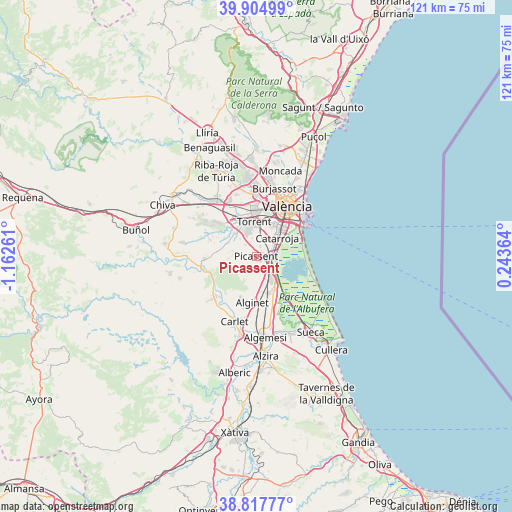
Picassent GPS coordinates[2]
39° 21' 48.6" North, 0° 27' 34.164" West
| Map corner | latitude | longitude |
|---|---|---|
| Upper-left | 39.90499°, | -1.16261° |
| Center: | 39.3635°, | -0.45949° |
| Lower-right: | 38.81777°, | 0.24364° |
| Map W x H: | 120.9×120.9 km | = 75.1×75.1mi |
| max Lat: | 43.74134° ⇑78.2% North |
| Picassent: | 39.3635° |
| min Lat: | ⇓21.8% South 27.64134° |
| min Long | Picassent | max Long |
| -18.00367° | -0.45949° | 4.2899° |
| W 82.2%⇐ | ⇒17.8% E |
Elevation
Elevation of Picassent is 53 m = 174 ft, and this is 545 m = 1788 ft below average elevation for this country.
| Max E: |
1682 m = 5518 ft | 90.9% |
| Avg. | 598 m = 1962 ft | |
| Picassent | 53 m = 174 ft | |
Min E: |
0 m = 0 ft | 9.1% |
See also: Spain elevation on elevation.city.
Geographical zone
Picassent is located in North temperate zone (between Tropic of Cancer and the Arctic Circle). Distance of this Northern Tropic circle is 1770.9 km =1100.4 mi to South.| Distance of | km | miles | from Picassent |
|---|---|---|---|
| North Pole | 5630.3 | 3498.5 | to North |
| Arctic Circle | 3024.4 | 1879.3 | to North |
| Tropic Cancer | 1770.9 | 1100.4 | to South |
| Equator | 4376.8 | 2719.6 | to South |


Nearby cities:
15 places around Picassent: (largest is in red/bold)
• Alaquàs
10.3 km =6.4 mi,  359°
359°
• Albal
5.5 km =3.4 mi,  42°
42°
• Alcàsser
1.4 km =0.9 mi,  69°
69°
• Alfafar
8.8 km =5.5 mi,  47°
47°
• Alginet
10.8 km =6.7 mi,  183°
183°
• Almussafes
9.6 km =6 mi,  157°
157°
• Benetússer
8.5 km =5.3 mi, 39°
• Benifaió
9.3 km =5.8 mi, 161°
• Beniparrell
4.3 km =2.7 mi,  59°
59°
• Catarroja
6.5 km =4 mi, 51°
• Paiporta
8 km =5 mi,  26°
26°
• Picanya
8.1 km =5 mi,  16°
16°
• Sedaví
10.2 km =6.3 mi, 40°
• Silla
4.1 km =2.5 mi,  91°
91°
• Torrent
8.2 km =5.1 mi, 356°
Sources, notices
• [Note1] Compared only with cities in Spain existing in our database
• [Src1] Map data: © OpenStreetMap contributors (CC-BY-SA)
• [Src2] Other city data from geonames.org with taken over terms of usage.
• [Src3] Geographical zone / Annual Mean Temperature by Robert A. Rohde @ Wikipedia
