Tresjuncos geodata
Tresjuncos (Castille-La Mancha) is a seat of a third-order administrative division; located in Spain in Europe/Madrid (GMT+2) time zone. With population of 438 people, there are 4032 cities with bigger population in this country. Compared to other cities in Spain, 74.4% of cities are located further ↑North; 58% of cities are located further ←West and 70% of cities have lower elevation than Tresjuncos. Note1
Administrative division(s):
- Level 1: Castille-La Mancha
- Level 2: Provincia de Cuenca
- Level 3: Tresjuncos


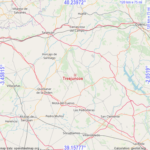
Tresjuncos GPS coordinates[2]
39° 42' 3.132" North, 2° 45' 18.072" West
| Map corner | latitude | longitude |
|---|---|---|
| Upper-left | 40.23972°, | -3.45815° |
| Center: | 39.70087°, | -2.75502° |
| Lower-right: | 39.15777°, | -2.0519° |
| Map W x H: | 120.3×120.3 km | = 74.8×74.8mi |
| max Lat: | 43.74134° ⇑74.4% North |
| Tresjuncos: | 39.70087° |
| min Lat: | ⇓25.6% South 27.64134° |
| min Long | Tresjuncos | max Long |
| -18.00367° | -2.75502° | 4.2899° |
| W 58%⇐ | ⇒42% E |
Elevation
Elevation of Tresjuncos is 814 m = 2671 ft, and this is 216 m = 709 ft above average elevation for this country.
| Max E: |
1682 m = 5518 ft | 30% |
| Tresjuncos | 814 m 2671 ft | |
| Avg. | 598 m = 1962 ft | |
Min E: |
0 m = 0 ft | 70% |
See also: Spain elevation on elevation.city.
Geographical zone
Tresjuncos is located in North temperate zone (between Tropic of Cancer and the Arctic Circle). Distance of this Northern Tropic circle is 1808.4 km =1123.7 mi to South.| Distance of | km | miles | from Tresjuncos |
|---|---|---|---|
| North Pole | 5592.7 | 3475.1 | to North |
| Arctic Circle | 2986.9 | 1856 | to North |
| Tropic Cancer | 1808.4 | 1123.7 | to South |
| Equator | 4414.3 | 2742.9 | to South |


Nearby cities:
15 places around Tresjuncos: (largest is in red/bold)
• Alconchel de la Estrella
15.7 km =9.8 mi,  82°
82°
• Almonacid del Marquesado
13.7 km =8.5 mi,  355°
355°
• Belmonte
16.5 km =10.3 mi,  164°
164°
• Fuentelespino de Haro
7.5 km =4.7 mi,  99°
99°
• Hontanaya
7 km =4.3 mi,  283°
283°
• Los Hinojosos
12.3 km =7.6 mi,  209°
209°
• Monreal del Llano
14.7 km =9.1 mi,  181°
181°
• Osa de la Vega
4.6 km =2.9 mi,  185°
185°
• Pozorrubio
21 km =13 mi,  307°
307°
• Puebla de Almenara
10.6 km =6.6 mi,  331°
331°
• Rada de Haro
18.5 km =11.5 mi,  141°
141°
• Villaescusa de Haro
13.3 km =8.3 mi,  148°
148°
• Villamayor de Santiago
14.8 km =9.2 mi, 282°
• Villar de Cañas
18.5 km =11.5 mi,  62°
62°
• Villarejo de Fuentes
10.9 km =6.8 mi,  27°
27°
Sources, notices
• [Note1] Compared only with cities in Spain existing in our database
• [Src1] Map data: © OpenStreetMap contributors (CC-BY-SA)
• [Src2] Other city data from geonames.org with taken over terms of usage.
• [Src3] Geographical zone / Annual Mean Temperature by Robert A. Rohde @ Wikipedia
