Los Hinojosos geodata
Los Hinojosos (Castille-La Mancha) is a populated place; located in Spain in Europe/Madrid (GMT+2) time zone. With population of 1,098 people, there are 2825 cities with bigger population in this country. Compared to other cities in Spain, 75.7% of cities are located further ↑North; 57.1% of cities are located further ←West and 64.1% of cities have lower elevation than Los Hinojosos. Note1
Administrative division(s):
- Level 1: Castille-La Mancha
- Level 2: Provincia de Cuenca
- Level 3: Hinojosos, Los


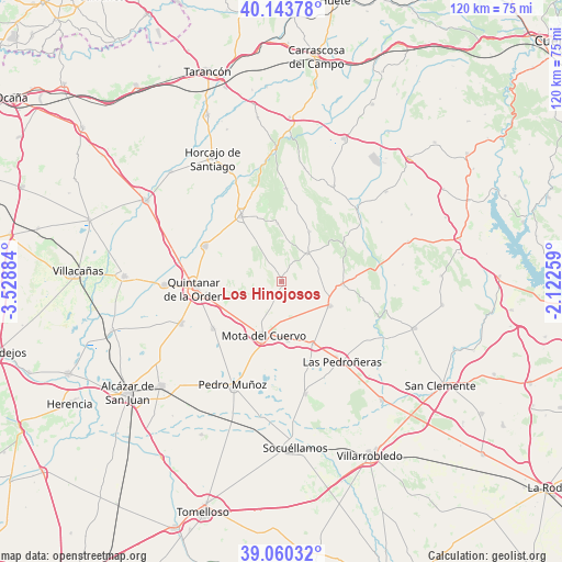
Los Hinojosos GPS coordinates[2]
39° 36' 15.012" North, 2° 49' 32.592" West
| Map corner | latitude | longitude |
|---|---|---|
| Upper-left | 40.14378°, | -3.52884° |
| Center: | 39.60417°, | -2.82572° |
| Lower-right: | 39.06032°, | -2.12259° |
| Map W x H: | 120.5×120.5 km | = 74.9×74.9mi |
| max Lat: | 43.74134° ⇑75.7% North |
| Los Hinojosos: | 39.60417° |
| min Lat: | ⇓24.3% South 27.64134° |
| min Long | Los Hinojosos | max Long |
| -18.00367° | -2.82572° | 4.2899° |
| W 57.1%⇐ | ⇒42.9% E |
Elevation
Elevation of Los Hinojosos is 772 m = 2533 ft, and this is 174 m = 571 ft above average elevation for this country.
| Max E: |
1682 m = 5518 ft | 35.9% |
| Los Hinojosos | 772 m 2533 ft | |
| Avg. | 598 m = 1962 ft | |
Min E: |
0 m = 0 ft | 64.1% |
See also: Spain elevation on elevation.city.
Geographical zone
Los Hinojosos is located in North temperate zone (between Tropic of Cancer and the Arctic Circle). Distance of this Northern Tropic circle is 1797.7 km =1117 mi to South.| Distance of | km | miles | from Los Hinojosos |
|---|---|---|---|
| North Pole | 5603.5 | 3481.9 | to North |
| Arctic Circle | 2997.6 | 1862.6 | to North |
| Tropic Cancer | 1797.7 | 1117 | to South |
| Equator | 4403.6 | 2736.3 | to South |


Nearby cities:
15 places around Los Hinojosos: (largest is in red/bold)
• Belmonte
11.6 km =7.2 mi,  116°
116°
• El Pedernoso
14.8 km =9.2 mi,  152°
152°
• El Toboso
17.8 km =11.1 mi,  235°
235°
• Fuentelespino de Haro
16.4 km =10.2 mi,  54°
54°
• Hontanaya
12.4 km =7.7 mi,  356°
356°
• Monreal del Llano
6.8 km =4.2 mi,  125°
125°
• Mota del Cuervo
12 km =7.5 mi,  198°
198°
• Osa de la Vega
8.4 km =5.2 mi,  42°
42°
• Quintanar de la Orden
18.5 km =11.5 mi,  266°
266°
• Rada de Haro
18 km =11.2 mi,  102°
102°
• Santa María de los Llanos
13.9 km =8.6 mi,  194°
194°
• Tresjuncos
12.3 km =7.6 mi,  29°
29°
• Villaescusa de Haro
13.1 km =8.1 mi,  92°
92°
• Villamayor de Santiago
16.4 km =10.2 mi,  329°
329°
• Villanueva de Alcardete
17.9 km =11.1 mi,  295°
295°
Sources, notices
• [Note1] Compared only with cities in Spain existing in our database
• [Src1] Map data: © OpenStreetMap contributors (CC-BY-SA)
• [Src2] Other city data from geonames.org with taken over terms of usage.
• [Src3] Geographical zone / Annual Mean Temperature by Robert A. Rohde @ Wikipedia
