Azután geodata
Azután (Castille-La Mancha) is a seat of a third-order administrative division; located in Spain in Europe/Madrid (GMT+2) time zone. With population of 324 people, there are 4411 cities with bigger population in this country. Compared to other cities in Spain, 73% of cities are located further ↑North; 74.1% of cities are located further →East and 72.6% of cities have higher elevation than Azután. Note1


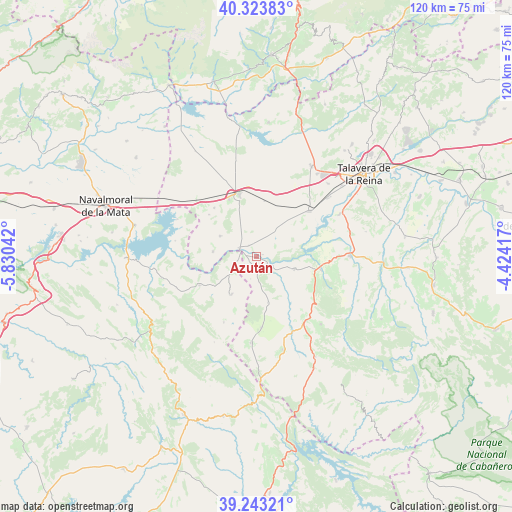
Azután GPS coordinates[2]
39° 47' 8.304" North, 5° 7' 38.28" West
| Map corner | latitude | longitude |
|---|---|---|
| Upper-left | 40.32383°, | -5.83042° |
| Center: | 39.78564°, | -5.1273° |
| Lower-right: | 39.24321°, | -4.42417° |
| Map W x H: | 120.2×120.2 km | = 74.7×74.7mi |
| max Lat: | 43.74134° ⇑73% North |
| Azután: | 39.78564° |
| min Lat: | ⇓27% South 27.64134° |
| min Long | Azután | max Long |
| -18.00367° | -5.1273° | 4.2899° |
| W 25.9%⇐ | ⇒74.1% E |
Elevation
Elevation of Azután is 337 m = 1106 ft, and this is 261 m = 856 ft below average elevation for this country.
| Max E: |
1682 m = 5518 ft | 72.6% |
| Avg. | 598 m = 1962 ft | |
| Azután | 337 m = 1106 ft | |
Min E: |
0 m = 0 ft | 27.4% |
See also: Spain elevation on elevation.city.
Geographical zone
Azután is located in North temperate zone (between Tropic of Cancer and the Arctic Circle). Distance of this Northern Tropic circle is 1817.8 km =1129.5 mi to South.| Distance of | km | miles | from Azután |
|---|---|---|---|
| North Pole | 5583.3 | 3469.3 | to North |
| Arctic Circle | 2977.4 | 1850.1 | to North |
| Tropic Cancer | 1817.8 | 1129.5 | to South |
| Equator | 4423.7 | 2748.8 | to South |


Nearby cities:
15 places around Azután: (largest is in red/bold)
• Alcañizo
13.2 km =8.2 mi,  7°
7°
• Alcolea de Tajo
3.2 km =2 mi,  327°
327°
• Aldeanueva de Barbarroya
9.4 km =5.8 mi,  108°
108°
• Belvis de la Jara
15.5 km =9.6 mi,  101°
101°
• Calera y Chozas
16.4 km =10.2 mi,  48°
48°
• Caleruela
14.9 km =9.3 mi,  311°
311°
• El Puente del Arzobispo
4.2 km =2.6 mi,  295°
295°
• Herreruela de Oropesa
15.2 km =9.4 mi,  319°
319°
• Lagartera
14.8 km =9.2 mi, 334°
• Navalmoralejo
5.3 km =3.3 mi,  195°
195°
• Oropesa
15.2 km =9.4 mi,  344°
344°
• Torrico
9.7 km =6 mi, 299°
• Valdelacasa de Tajo
14.9 km =9.3 mi,  243°
243°
• Valdeverdeja
10.2 km =6.3 mi,  276°
276°
• Villar del Pedroso
10.6 km =6.6 mi,  213°
213°
Sources, notices
• [Note1] Compared only with cities in Spain existing in our database
• [Src1] Map data: © OpenStreetMap contributors (CC-BY-SA)
• [Src2] Other city data from geonames.org with taken over terms of usage.
• [Src3] Geographical zone / Annual Mean Temperature by Robert A. Rohde @ Wikipedia
