Calera y Chozas geodata
Calera y Chozas (Castille-La Mancha) is a seat of a third-order administrative division; located in Spain in Europe/Madrid (GMT+2) time zone. With population of 4,124 people, there are 1447 cities with bigger population in this country. Compared to other cities in Spain, 71.9% of cities are located further ↑North; 72.3% of cities are located further →East and 69.6% of cities have higher elevation than Calera y Chozas. Note1
Administrative division(s):
- Level 1: Castille-La Mancha
- Level 2: Province of Toledo
- Level 3: Calera y Chozas


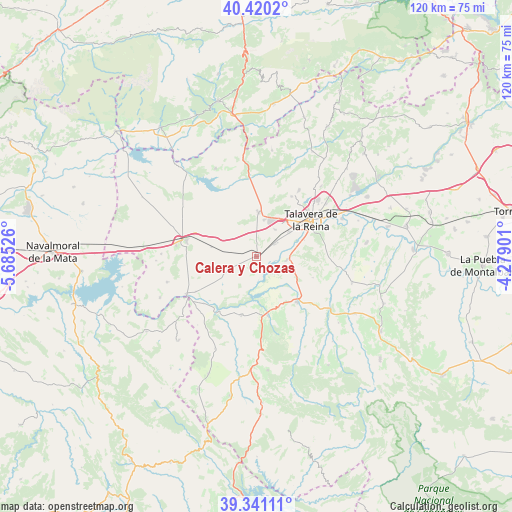
Calera y Chozas GPS coordinates[2]
39° 52' 58.008" North, 4° 58' 55.668" West
| Map corner | latitude | longitude |
|---|---|---|
| Upper-left | 40.4202°, | -5.68526° |
| Center: | 39.88278°, | -4.98213° |
| Lower-right: | 39.34111°, | -4.27901° |
| Map W x H: | 120×120 km | = 74.6×74.6mi |
| max Lat: | 43.74134° ⇑71.9% North |
| Calera y Chozas: | 39.88278° |
| min Lat: | ⇓28.1% South 27.64134° |
| min Long | Calera y Chozas | max Long |
| -18.00367° | -4.98213° | 4.2899° |
| W 27.7%⇐ | ⇒72.3% E |
Elevation
Elevation of Calera y Chozas is 389 m = 1276 ft, and this is 209 m = 686 ft below average elevation for this country.
| Max E: |
1682 m = 5518 ft | 69.6% |
| Avg. | 598 m = 1962 ft | |
| Calera y Chozas | 389 m = 1276 ft | |
Min E: |
0 m = 0 ft | 30.4% |
See also: Spain elevation on elevation.city.
Geographical zone
Calera y Chozas is located in North temperate zone (between Tropic of Cancer and the Arctic Circle). Distance of this Northern Tropic circle is 1828.6 km =1136.2 mi to South.| Distance of | km | miles | from Calera y Chozas |
|---|---|---|---|
| North Pole | 5572.5 | 3462.6 | to North |
| Arctic Circle | 2966.6 | 1843.4 | to North |
| Tropic Cancer | 1828.6 | 1136.2 | to South |
| Equator | 4434.5 | 2755.5 | to South |


Nearby cities:
15 places around Calera y Chozas: (largest is in red/bold)
• Alcañizo
10.8 km =6.7 mi,  282°
282°
• Alcolea de Tajo
16.3 km =10.1 mi,  240°
240°
• Aldeanueva de Barbarroya
14.2 km =8.8 mi,  194°
194°
• Azután
16.4 km =10.2 mi,  228°
228°
• Belvis de la Jara
14.2 km =8.8 mi,  168°
168°
• El Puente del Arzobispo
18.5 km =11.5 mi, 240°
• Gamonal
8.8 km =5.5 mi,  11°
11°
• Lagartera
18.9 km =11.7 mi, 277°
• Las Herencias
5.3 km =3.3 mi,  106°
106°
• Mejorada
16.4 km =10.2 mi,  30°
30°
• Oropesa
16.8 km =10.4 mi, 283°
• Segurilla
18.6 km =11.6 mi, 32°
• Talavera de la Reina
15.7 km =9.8 mi,  55°
55°
• Torralba de Oropesa
15.7 km =9.8 mi,  291°
291°
• Velada
10.5 km =6.5 mi,  2°
2°
Sources, notices
• [Note1] Compared only with cities in Spain existing in our database
• [Src1] Map data: © OpenStreetMap contributors (CC-BY-SA)
• [Src2] Other city data from geonames.org with taken over terms of usage.
• [Src3] Geographical zone / Annual Mean Temperature by Robert A. Rohde @ Wikipedia
