Navalmoralejo geodata
Navalmoralejo (Castille-La Mancha) is a seat of a third-order administrative division; located in Spain in Europe/Madrid (GMT+2) time zone. With population of 70 people, there are 6241 cities with bigger population in this country. Compared to other cities in Spain, 73.7% of cities are located further ↑North; 74.3% of cities are located further →East and 67.3% of cities have higher elevation than Navalmoralejo. Note1
Administrative division(s):
- Level 1: Castille-La Mancha
- Level 2: Province of Toledo
- Level 3: Navalmoralejo


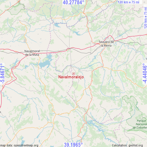
Navalmoralejo GPS coordinates[2]
39° 44' 21.444" North, 5° 8' 36.924" West
| Map corner | latitude | longitude |
|---|---|---|
| Upper-left | 40.27784°, | -5.84671° |
| Center: | 39.73929°, | -5.14359° |
| Lower-right: | 39.1965°, | -4.44046° |
| Map W x H: | 120.2×120.2 km | = 74.7×74.7mi |
| max Lat: | 43.74134° ⇑73.7% North |
| Navalmoralejo: | 39.73929° |
| min Lat: | ⇓26.3% South 27.64134° |
| min Long | Navalmoralejo | max Long |
| -18.00367° | -5.14359° | 4.2899° |
| W 25.7%⇐ | ⇒74.3% E |
Elevation
Elevation of Navalmoralejo is 428 m = 1404 ft, and this is 170 m = 558 ft below average elevation for this country.
| Max E: |
1682 m = 5518 ft | 67.3% |
| Avg. | 598 m = 1962 ft | |
| Navalmoralejo | 428 m = 1404 ft | |
Min E: |
0 m = 0 ft | 32.7% |
See also: Spain elevation on elevation.city.
Geographical zone
Navalmoralejo is located in North temperate zone (between Tropic of Cancer and the Arctic Circle). Distance of this Northern Tropic circle is 1812.7 km =1126.4 mi to South.| Distance of | km | miles | from Navalmoralejo |
|---|---|---|---|
| North Pole | 5588.5 | 3472.5 | to North |
| Arctic Circle | 2982.6 | 1853.3 | to North |
| Tropic Cancer | 1812.7 | 1126.4 | to South |
| Equator | 4418.6 | 2745.6 | to South |


Nearby cities:
15 places around Navalmoralejo: (largest is in red/bold)
• Alcolea de Tajo
7.8 km =4.8 mi,  357°
357°
• Aldeanueva de Barbarroya
10.6 km =6.6 mi,  77°
77°
• Aldeanueva de San Bartolomé
11.8 km =7.3 mi,  167°
167°
• Azután
5.3 km =3.3 mi,  15°
15°
• Belvis de la Jara
16.7 km =10.4 mi, 82°
• Caleruela
17.9 km =11.1 mi,  327°
327°
• Carrascalejo
13.3 km =8.3 mi,  207°
207°
• El Puente del Arzobispo
7.3 km =4.5 mi,  340°
340°
• Garvín
17.5 km =10.9 mi,  262°
262°
• La Nava de Ricomalillo
16.4 km =10.2 mi,  127°
127°
• Mohedas de la Jara
15 km =9.3 mi,  179°
179°
• Torrico
12.2 km =7.6 mi,  324°
324°
• Valdelacasa de Tajo
12 km =7.5 mi, 262°
• Valdeverdeja
10.8 km =6.7 mi,  306°
306°
• Villar del Pedroso
5.8 km =3.6 mi,  230°
230°
Sources, notices
• [Note1] Compared only with cities in Spain existing in our database
• [Src1] Map data: © OpenStreetMap contributors (CC-BY-SA)
• [Src2] Other city data from geonames.org with taken over terms of usage.
• [Src3] Geographical zone / Annual Mean Temperature by Robert A. Rohde @ Wikipedia
