Alcañizo geodata
Alcañizo (Castille-La Mancha) is a seat of a third-order administrative division; located in Spain in Europe/Madrid (GMT+2) time zone. With population of 314 people, there are 4446 cities with bigger population in this country. Compared to other cities in Spain, 71.5% of cities are located further ↑North; 73.8% of cities are located further →East and 70.2% of cities have higher elevation than Alcañizo. Note1
Administrative division(s):
- Level 1: Castille-La Mancha
- Level 2: Province of Toledo
- Level 3: Alcañizo


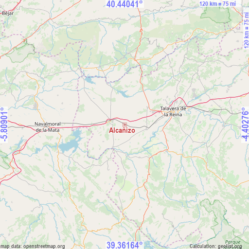
Alcañizo GPS coordinates[2]
39° 54' 11.34" North, 5° 6' 21.168" West
| Map corner | latitude | longitude |
|---|---|---|
| Upper-left | 40.44041°, | -5.80901° |
| Center: | 39.90315°, | -5.10588° |
| Lower-right: | 39.36164°, | -4.40276° |
| Map W x H: | 119.9×119.9 km | = 74.5×74.5mi |
| max Lat: | 43.74134° ⇑71.5% North |
| Alcañizo: | 39.90315° |
| min Lat: | ⇓28.5% South 27.64134° |
| min Long | Alcañizo | max Long |
| -18.00367° | -5.10588° | 4.2899° |
| W 26.2%⇐ | ⇒73.8% E |
Elevation
Elevation of Alcañizo is 377 m = 1237 ft, and this is 221 m = 725 ft below average elevation for this country.
| Max E: |
1682 m = 5518 ft | 70.2% |
| Avg. | 598 m = 1962 ft | |
| Alcañizo | 377 m = 1237 ft | |
Min E: |
0 m = 0 ft | 29.8% |
See also: Spain elevation on elevation.city.
Geographical zone
Alcañizo is located in North temperate zone (between Tropic of Cancer and the Arctic Circle). Distance of this Northern Tropic circle is 1830.9 km =1137.7 mi to South.| Distance of | km | miles | from Alcañizo |
|---|---|---|---|
| North Pole | 5570.2 | 3461.2 | to North |
| Arctic Circle | 2964.4 | 1842 | to North |
| Tropic Cancer | 1830.9 | 1137.7 | to South |
| Equator | 4436.8 | 2756.9 | to South |


Nearby cities:
15 places around Alcañizo: (largest is in red/bold)
• Alcolea de Tajo
11 km =6.8 mi,  198°
198°
• Azután
13.2 km =8.2 mi,  187°
187°
• Calera y Chozas
10.8 km =6.7 mi,  102°
102°
• Caleruela
13.3 km =8.3 mi,  256°
256°
• El Puente del Arzobispo
12.6 km =7.8 mi,  206°
206°
• Gamonal
13.8 km =8.6 mi,  62°
62°
• Herreruela de Oropesa
11.8 km =7.3 mi, 262°
• La Calzada de Oropesa
14.7 km =9.1 mi,  267°
267°
• Lagartera
8.2 km =5.1 mi, 271°
• Las Herencias
16.1 km =10 mi, 103°
• Oropesa
6 km =3.7 mi,  285°
285°
• Torralba de Oropesa
5.3 km =3.3 mi,  309°
309°
• Torrico
13.1 km =8.1 mi,  231°
231°
• Valdeverdeja
16.8 km =10.4 mi, 225°
• Velada
13.7 km =8.5 mi,  53°
53°
Sources, notices
• [Note1] Compared only with cities in Spain existing in our database
• [Src1] Map data: © OpenStreetMap contributors (CC-BY-SA)
• [Src2] Other city data from geonames.org with taken over terms of usage.
• [Src3] Geographical zone / Annual Mean Temperature by Robert A. Rohde @ Wikipedia
