Almuñécar geodata
Almuñécar (Andalusia) is a seat of a third-order administrative division; located in Spain in Europe/Madrid (GMT+2) time zone. With population of 27,696 people, there are 336 cities with bigger population in this country. Compared to other cities in Spain, 97.3% of cities are located further ↑North; 55.2% of cities are located further →East and 95.1% of cities have higher elevation than Almuñécar. Note1


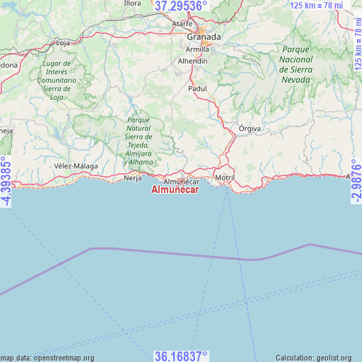
Almuñécar GPS coordinates[2]
36° 44' 2.148" North, 3° 41' 26.592" West
| Map corner | latitude | longitude |
|---|---|---|
| Upper-left | 37.29536°, | -4.39385° |
| Center: | 36.73393°, | -3.69072° |
| Lower-right: | 36.16837°, | -2.9876° |
| Map W x H: | 125.3×125.3 km | = 77.9×77.9mi |
| max Lat: | 43.74134° ⇑97.3% North |
| Almuñécar: | 36.73393° |
| min Lat: | ⇓2.7% South 27.64134° |
| min Long | Almuñécar | max Long |
| -18.00367° | -3.69072° | 4.2899° |
| W 44.8%⇐ | ⇒55.2% E |
Elevation
Elevation of Almuñécar is 24 m = 79 ft, and this is 574 m = 1883 ft below average elevation for this country.
| Max E: |
1682 m = 5518 ft | 95.1% |
| Avg. | 598 m = 1962 ft | |
| Almuñécar | 24 m = 79 ft | |
Min E: |
0 m = 0 ft | 4.9% |
See also: Spain elevation on elevation.city.
Geographical zone
Almuñécar is located in North temperate zone (between Tropic of Cancer and the Arctic Circle). Distance of this Northern Tropic circle is 1478.5 km =918.7 mi to South.| Distance of | km | miles | from Almuñécar |
|---|---|---|---|
| North Pole | 5922.6 | 3680.1 | to North |
| Arctic Circle | 3316.7 | 2060.9 | to North |
| Tropic Cancer | 1478.5 | 918.7 | to South |
| Equator | 4084.4 | 2537.9 | to South |


Nearby cities:
15 places around Almuñécar: (largest is in red/bold)
• Albuñuelas
22.2 km =13.8 mi,  13°
13°
• El Varadero
15.1 km =9.4 mi,  93°
93°
• Frigiliana
19.1 km =11.9 mi,  288°
288°
• Jete
7.3 km =4.5 mi,  16°
16°
• La Herradura
4.2 km =2.6 mi,  271°
271°
• Lentegí
11.5 km =7.1 mi, 7°
• Molvízar
9.4 km =5.8 mi,  51°
51°
• Motril
15.5 km =9.6 mi,  83°
83°
• Nerja
16.5 km =10.3 mi,  277°
277°
• Otívar
9.2 km =5.7 mi, 6°
• Salobreña
9.3 km =5.8 mi, 83°
• Torrenueva
18.2 km =11.3 mi,  100°
100°
• Torrox
23.5 km =14.6 mi, 276°
• Vélez de Benaudalla
19.1 km =11.9 mi, 54°
• Ítrabo
8.7 km =5.4 mi,  32°
32°
Sources, notices
• [Note1] Compared only with cities in Spain existing in our database
• [Src1] Map data: © OpenStreetMap contributors (CC-BY-SA)
• [Src2] Other city data from geonames.org with taken over terms of usage.
• [Src3] Geographical zone / Annual Mean Temperature by Robert A. Rohde @ Wikipedia
