Jete geodata
Jete (Andalusia) is a seat of a third-order administrative division; located in Spain in Europe/Madrid (GMT+2) time zone. In our database, there are 6762 cities with bigger population. Compared to other cities in Spain, 96.8% of cities are located further ↑North; 54.8% of cities are located further →East and 84.5% of cities have higher elevation than Jete. Note1


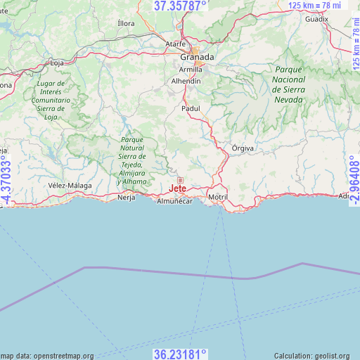
Jete GPS coordinates[2]
36° 47' 48.876" North, 3° 40' 1.92" West
| Map corner | latitude | longitude |
|---|---|---|
| Upper-left | 37.35787°, | -4.37033° |
| Center: | 36.79691°, | -3.6672° |
| Lower-right: | 36.23181°, | -2.96408° |
| Map W x H: | 125.2×125.2 km | = 77.8×77.8mi |
| max Lat: | 43.74134° ⇑96.8% North |
| Jete: | 36.79691° |
| min Lat: | ⇓3.2% South 27.64134° |
| min Long | Jete | max Long |
| -18.00367° | -3.6672° | 4.2899° |
| W 45.2%⇐ | ⇒54.8% E |
Elevation
Elevation of Jete is 147 m = 482 ft, and this is 451 m = 1480 ft below average elevation for this country.
| Max E: |
1682 m = 5518 ft | 84.5% |
| Avg. | 598 m = 1962 ft | |
| Jete | 147 m = 482 ft | |
Min E: |
0 m = 0 ft | 15.5% |
See also: Spain elevation on elevation.city.
Geographical zone
Jete is located in North temperate zone (between Tropic of Cancer and the Arctic Circle). Distance of this Northern Tropic circle is 1485.5 km =923 mi to South.| Distance of | km | miles | from Jete |
|---|---|---|---|
| North Pole | 5915.6 | 3675.8 | to North |
| Arctic Circle | 3309.7 | 2056.6 | to North |
| Tropic Cancer | 1485.5 | 923 | to South |
| Equator | 4091.4 | 2542.3 | to South |


Nearby cities:
15 places around Jete: (largest is in red/bold)
• Albuñuelas
14.9 km =9.3 mi,  12°
12°
• Almuñécar
7.3 km =4.5 mi,  196°
196°
• El Varadero
15.2 km =9.4 mi,  121°
121°
• Frigiliana
20.3 km =12.6 mi,  267°
267°
• La Herradura
9.3 km =5.8 mi,  222°
222°
• Lanjarón
21.3 km =13.2 mi,  50°
50°
• Lentegí
4.4 km =2.7 mi,  351°
351°
• Molvízar
5.4 km =3.4 mi,  103°
103°
• Motril
14.3 km =8.9 mi,  111°
111°
• Nerja
19.1 km =11.9 mi,  255°
255°
• Otívar
2.4 km =1.5 mi,  331°
331°
• Salobreña
9.3 km =5.8 mi,  130°
130°
• Torrenueva
18.9 km =11.7 mi, 123°
• Vélez de Benaudalla
14.1 km =8.8 mi,  73°
73°
• Ítrabo
2.5 km =1.6 mi,  82°
82°
Sources, notices
• [Note1] Compared only with cities in Spain existing in our database
• [Src1] Map data: © OpenStreetMap contributors (CC-BY-SA)
• [Src2] Other city data from geonames.org with taken over terms of usage.
• [Src3] Geographical zone / Annual Mean Temperature by Robert A. Rohde @ Wikipedia
