Vélez de Benaudalla geodata
Vélez de Benaudalla (Andalusia) is a seat of a third-order administrative division; located in Spain in Europe/Madrid (GMT+2) time zone. With population of 2,618 people, there are 1852 cities with bigger population in this country. Compared to other cities in Spain, 96.6% of cities are located further ↑North; 52.4% of cities are located further →East and 82.3% of cities have higher elevation than Vélez de Benaudalla. Note1
Administrative division(s):
- Level 1: Andalusia
- Level 2: Provincia de Granada
- Level 3: Vélez de Benaudalla


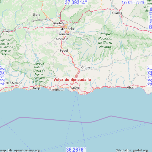
Vélez de Benaudalla GPS coordinates[2]
36° 49' 56.784" North, 3° 30' 55.404" West
| Map corner | latitude | longitude |
|---|---|---|
| Upper-left | 37.39314°, | -4.21852° |
| Center: | 36.83244°, | -3.51539° |
| Lower-right: | 36.2676°, | -2.81227° |
| Map W x H: | 125.1×125.1 km | = 77.7×77.7mi |
| max Lat: | 43.74134° ⇑96.6% North |
| Vélez de Benaudalla: | 36.83244° |
| min Lat: | ⇓3.4% South 27.64134° |
| min Long | Vélez de Benau | max Long |
| -18.00367° | -3.51539° | 4.2899° |
| W 47.6%⇐ | ⇒52.4% E |
Elevation
Elevation of Vélez de Benaudalla is 181 m = 594 ft, and this is 417 m = 1368 ft below average elevation for this country.
| Max E: |
1682 m = 5518 ft | 82.3% |
| Avg. | 598 m = 1962 ft | |
| Vélez de Benaudalla | 181 m = 594 ft | |
Min E: |
0 m = 0 ft | 17.7% |
See also: Spain elevation on elevation.city.
Geographical zone
Vélez de Benaudalla is located in North temperate zone (between Tropic of Cancer and the Arctic Circle). Distance of this Northern Tropic circle is 1489.5 km =925.5 mi to South.| Distance of | km | miles | from Vélez de Benaudalla |
|---|---|---|---|
| North Pole | 5911.7 | 3673.4 | to North |
| Arctic Circle | 3305.8 | 2054.1 | to North |
| Tropic Cancer | 1489.5 | 925.5 | to South |
| Equator | 4095.4 | 2544.8 | to South |


Nearby cities:
15 places around Vélez de Benaudalla: (largest is in red/bold)
• Carataunas
13.8 km =8.6 mi,  43°
43°
• Cáñar
13.1 km =8.1 mi, 36°
• El Varadero
11.9 km =7.4 mi,  182°
182°
• Jete
14.1 km =8.8 mi,  253°
253°
• Lanjarón
10 km =6.2 mi,  17°
17°
• Lentegí
14.1 km =8.8 mi,  271°
271°
• Lújar
11.1 km =6.9 mi,  116°
116°
• Molvízar
9.7 km =6 mi,  237°
237°
• Motril
9.1 km =5.7 mi, 181°
• Otívar
14.7 km =9.1 mi,  262°
262°
• Salobreña
11.8 km =7.3 mi,  212°
212°
• Soportújar
14.5 km =9 mi, 42°
• Torrenueva
14.5 km =9 mi,  170°
170°
• Ítrabo
11.6 km =7.2 mi, 251°
• Órgiva
11.3 km =7 mi,  46°
46°
Sources, notices
• [Note1] Compared only with cities in Spain existing in our database
• [Src1] Map data: © OpenStreetMap contributors (CC-BY-SA)
• [Src2] Other city data from geonames.org with taken over terms of usage.
• [Src3] Geographical zone / Annual Mean Temperature by Robert A. Rohde @ Wikipedia
