Albuñuelas geodata
Albuñuelas (Andalusia) is a seat of a third-order administrative division; located in Spain in Europe/Madrid (GMT+2) time zone. With population of 1,063 people, there are 2860 cities with bigger population in this country. Compared to other cities in Spain, 95.9% of cities are located further ↑North; 54.2% of cities are located further →East and 58.1% of cities have lower elevation than Albuñuelas. Note1


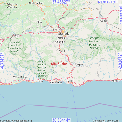
Albuñuelas GPS coordinates[2]
36° 55' 41.808" North, 3° 37' 54.624" West
| Map corner | latitude | longitude |
|---|---|---|
| Upper-left | 37.48827°, | -4.33497° |
| Center: | 36.92828°, | -3.63184° |
| Lower-right: | 36.36414°, | -2.92872° |
| Map W x H: | 125×125 km | = 77.7×77.7mi |
| max Lat: | 43.74134° ⇑95.9% North |
| Albuñuelas: | 36.92828° |
| min Lat: | ⇓4.1% South 27.64134° |
| min Long | Albuñuelas | max Long |
| -18.00367° | -3.63184° | 4.2899° |
| W 45.8%⇐ | ⇒54.2% E |
Elevation
Elevation of Albuñuelas is 730 m = 2395 ft, and this is 132 m = 433 ft above average elevation for this country.
| Max E: |
1682 m = 5518 ft | 41.9% |
| Albuñuelas | 730 m 2395 ft | |
| Avg. | 598 m = 1962 ft | |
Min E: |
0 m = 0 ft | 58.1% |
See also: Spain elevation on elevation.city.
Geographical zone
Albuñuelas is located in North temperate zone (between Tropic of Cancer and the Arctic Circle). Distance of this Northern Tropic circle is 1500.1 km =932.1 mi to South.| Distance of | km | miles | from Albuñuelas |
|---|---|---|---|
| North Pole | 5901 | 3666.7 | to North |
| Arctic Circle | 3295.1 | 2047.5 | to North |
| Tropic Cancer | 1500.1 | 932.1 | to South |
| Equator | 4106 | 2551.3 | to South |


Nearby cities:
15 places around Albuñuelas: (largest is in red/bold)
• Cáñar
18.1 km =11.2 mi,  90°
90°
• Dílar
16.3 km =10.1 mi,  9°
9°
• Dúrcal
8.8 km =5.5 mi,  41°
41°
• Jayena
17.2 km =10.7 mi,  277°
277°
• Jete
14.9 km =9.3 mi,  192°
192°
• Lanjarón
13.4 km =8.3 mi, 94°
• Lentegí
10.9 km =6.8 mi,  200°
200°
• Molvízar
16 km =9.9 mi,  172°
172°
• Nigüelas
9.9 km =6.2 mi,  56°
56°
• Otura
17.8 km =11.1 mi,  359°
359°
• Otívar
13.2 km =8.2 mi, 198°
• Padul
10.7 km =6.6 mi,  2°
2°
• Vélez de Benaudalla
14.9 km =9.3 mi,  135°
135°
• Ítrabo
14.3 km =8.9 mi,  182°
182°
• Órgiva
18.7 km =11.6 mi,  98°
98°
Sources, notices
• [Note1] Compared only with cities in Spain existing in our database
• [Src1] Map data: © OpenStreetMap contributors (CC-BY-SA)
• [Src2] Other city data from geonames.org with taken over terms of usage.
• [Src3] Geographical zone / Annual Mean Temperature by Robert A. Rohde @ Wikipedia
