Almogía geodata
Almogía (Andalusia) is a seat of a third-order administrative division; located in Spain in Europe/Madrid (GMT+2) time zone. With population of 4,231 people, there are 1434 cities with bigger population in this country. Compared to other cities in Spain, 96.6% of cities are located further ↑North; 66.7% of cities are located further →East and 69.9% of cities have higher elevation than Almogía. Note1


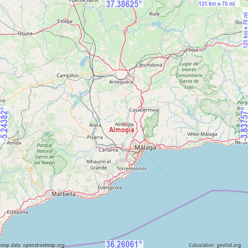
Almogía GPS coordinates[2]
36° 49' 31.8" North, 4° 32' 26.52" West
| Map corner | latitude | longitude |
|---|---|---|
| Upper-left | 37.38625°, | -5.24382° |
| Center: | 36.8255°, | -4.5407° |
| Lower-right: | 36.26061°, | -3.83757° |
| Map W x H: | 125.2×125.2 km | = 77.8×77.8mi |
| max Lat: | 43.74134° ⇑96.6% North |
| Almogía: | 36.8255° |
| min Lat: | ⇓3.4% South 27.64134° |
| min Long | Almogía | max Long |
| -18.00367° | -4.5407° | 4.2899° |
| W 33.3%⇐ | ⇒66.7% E |
Elevation
Elevation of Almogía is 381 m = 1250 ft, and this is 217 m = 712 ft below average elevation for this country.
| Max E: |
1682 m = 5518 ft | 69.9% |
| Avg. | 598 m = 1962 ft | |
| Almogía | 381 m = 1250 ft | |
Min E: |
0 m = 0 ft | 30.1% |
See also: Spain elevation on elevation.city.
Geographical zone
Almogía is located in North temperate zone (between Tropic of Cancer and the Arctic Circle). Distance of this Northern Tropic circle is 1488.7 km =925 mi to South.| Distance of | km | miles | from Almogía |
|---|---|---|---|
| North Pole | 5912.5 | 3673.9 | to North |
| Arctic Circle | 3306.6 | 2054.6 | to North |
| Tropic Cancer | 1488.7 | 925 | to South |
| Equator | 4094.6 | 2544.3 | to South |


Nearby cities:
15 places around Almogía: (largest is in red/bold)
• Alhaurín de la Torre
18.1 km =11.2 mi,  185°
185°
• Alhaurín el Grande
24.1 km =15 mi,  212°
212°
• Alora
14.7 km =9.1 mi,  269°
269°
• Antequera
21.6 km =13.4 mi,  355°
355°
• Carratraca
25 km =15.5 mi,  276°
276°
• Casabermeja
12.4 km =7.7 mi,  53°
53°
• Colmenar
20.3 km =12.6 mi,  64°
64°
• Cártama
15.2 km =9.4 mi, 212°
• Estación de Cártama
12.3 km =7.6 mi, 213°
• Málaga
15.9 km =9.9 mi,  137°
137°
• Pizarra
16.4 km =10.2 mi,  245°
245°
• Ríogordo
24.3 km =15.1 mi,  65°
65°
• Torremolinos
23.1 km =14.4 mi,  170°
170°
• Totalán
22.7 km =14.1 mi,  107°
107°
• Villanueva del Rosario
24.6 km =15.3 mi,  39°
39°
Sources, notices
• [Note1] Compared only with cities in Spain existing in our database
• [Src1] Map data: © OpenStreetMap contributors (CC-BY-SA)
• [Src2] Other city data from geonames.org with taken over terms of usage.
• [Src3] Geographical zone / Annual Mean Temperature by Robert A. Rohde @ Wikipedia
