Ríogordo geodata
Ríogordo (Andalusia) is a populated place; located in Spain in Europe/Madrid (GMT+2) time zone. With population of 2,954 people, there are 1739 cities with bigger population in this country. Compared to other cities in Spain, 96% of cities are located further ↑North; 63.7% of cities are located further →East and 68.1% of cities have higher elevation than Ríogordo. Note1


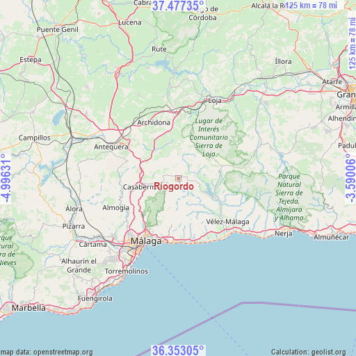
Ríogordo GPS coordinates[2]
36° 55' 2.172" North, 4° 17' 35.448" West
| Map corner | latitude | longitude |
|---|---|---|
| Upper-left | 37.47735°, | -4.99631° |
| Center: | 36.91727°, | -4.29318° |
| Lower-right: | 36.35305°, | -3.59006° |
| Map W x H: | 125×125 km | = 77.7×77.7mi |
| max Lat: | 43.74134° ⇑96% North |
| Ríogordo: | 36.91727° |
| min Lat: | ⇓4% South 27.64134° |
| min Long | Ríogordo | max Long |
| -18.00367° | -4.29318° | 4.2899° |
| W 36.3%⇐ | ⇒63.7% E |
Elevation
Elevation of Ríogordo is 414 m = 1358 ft, and this is 184 m = 604 ft below average elevation for this country.
| Max E: |
1682 m = 5518 ft | 68.1% |
| Avg. | 598 m = 1962 ft | |
| Ríogordo | 414 m = 1358 ft | |
Min E: |
0 m = 0 ft | 31.9% |
See also: Spain elevation on elevation.city.
Geographical zone
Ríogordo is located in North temperate zone (between Tropic of Cancer and the Arctic Circle). Distance of this Northern Tropic circle is 1498.9 km =931.4 mi to South.| Distance of | km | miles | from Ríogordo |
|---|---|---|---|
| North Pole | 5902.2 | 3667.5 | to North |
| Arctic Circle | 3296.4 | 2048.3 | to North |
| Tropic Cancer | 1498.9 | 931.4 | to South |
| Equator | 4104.8 | 2550.6 | to South |


Nearby cities:
15 places around Ríogordo: (largest is in red/bold)
• Alcaucín
16 km =9.9 mi,  95°
95°
• Alfarnate
9.1 km =5.7 mi,  19°
19°
• Alfarnatejo
9.2 km =5.7 mi, 18°
• Almáchar
13.9 km =8.6 mi,  150°
150°
• Benamargosa
12.7 km =7.9 mi,  135°
135°
• Borge
12.5 km =7.8 mi,  155°
155°
• Casabermeja
12.4 km =7.7 mi,  257°
257°
• Colmenar
4 km =2.5 mi,  250°
250°
• Comares
8.6 km =5.3 mi, 151°
• Cútar
11.2 km =7 mi, 148°
• Periana
9.1 km =5.7 mi,  81°
81°
• Villanueva del Rosario
10.9 km =6.8 mi,  324°
324°
• Villanueva del Trabuco
13 km =8.1 mi,  341°
341°
• Viñuela
14.8 km =9.2 mi,  114°
114°
• Zafarraya
14.7 km =9.1 mi,  63°
63°
Sources, notices
• [Note1] Compared only with cities in Spain existing in our database
• [Src1] Map data: © OpenStreetMap contributors (CC-BY-SA)
• [Src2] Other city data from geonames.org with taken over terms of usage.
• [Src3] Geographical zone / Annual Mean Temperature by Robert A. Rohde @ Wikipedia
