Almagro geodata
Almagro (Castille-La Mancha) is a seat of a third-order administrative division; located in Spain in Europe/Madrid (GMT+2) time zone. With population of 8,546 people, there are 909 cities with bigger population in this country. Compared to other cities in Spain, 82.3% of cities are located further ↑North; 55.6% of cities are located further →East and 50.6% of cities have higher elevation than Almagro. Note1
Administrative division(s):
- Level 1: Castille-La Mancha
- Level 2: Provincia de Ciudad Real
- Level 3: Almagro


Almagro GPS coordinates[2]
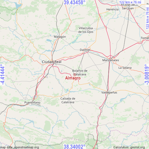
38° 53' 21.876" North, 3° 42' 40.716" West
| Map corner | latitude | longitude |
|---|---|---|
| Upper-left | 39.43458°, | -4.41444° |
| Center: | 38.88941°, | -3.71131° |
| Lower-right: | 38.34002°, | -3.00819° |
| Map W x H: | 121.7×121.7 km | = 75.6×75.6mi |
| max Lat: | 43.74134° ⇑82.3% North |
| Almagro: | 38.88941° |
| min Lat: | ⇓17.7% South 27.64134° |
| min Long | Almagro | max Long |
| -18.00367° | -3.71131° | 4.2899° |
| W 44.4%⇐ | ⇒55.6% E |
Elevation
Elevation of Almagro is 651 m = 2136 ft, and this is 53 m = 174 ft above average elevation for this country.
| Max E: |
1682 m = 5518 ft | 50.6% |
| Almagro | 651 m 2136 ft | |
| Avg. | 598 m = 1962 ft | |
Min E: |
0 m = 0 ft | 49.4% |
See also: Spain elevation on elevation.city.
Geographical zone
Almagro is located in North temperate zone (between Tropic of Cancer and the Arctic Circle). Distance of this Northern Tropic circle is 1718.2 km =1067.6 mi to South.| Distance of | km | miles | from Almagro |
|---|---|---|---|
| North Pole | 5683 | 3531.3 | to North |
| Arctic Circle | 3077.1 | 1912 | to North |
| Tropic Cancer | 1718.2 | 1067.6 | to South |
| Equator | 4324.1 | 2686.9 | to South |


Nearby cities:
15 places around Almagro: (largest is in red/bold)
• Aldea del Rey
20.2 km =12.6 mi,  213°
213°
• Ballesteros de Calatrava
21.1 km =13.1 mi,  253°
253°
• Bolaños de Calatrava
4.6 km =2.9 mi,  64°
64°
• Carrión de Calatrava
17.1 km =10.6 mi,  327°
327°
• Cañada de Calatrava
27.1 km =16.8 mi,  261°
261°
• Ciudad Real
21.7 km =13.5 mi,  299°
299°
• Daimiel
21.7 km =13.5 mi,  22°
22°
• Granátula de Calatrava
10.7 km =6.6 mi,  195°
195°
• La Calzada de Calatrava
21.4 km =13.3 mi, 195°
• Miguelturra
17.6 km =10.9 mi, 298°
• Moral de Calatrava
13.3 km =8.3 mi,  119°
119°
• Poblete
23.9 km =14.9 mi,  282°
282°
• Torralba de Calatrava
14.7 km =9.1 mi,  346°
346°
• Valenzuela de Calatrava
6.7 km =4.2 mi,  232°
232°
• Villar del Pozo
22.3 km =13.9 mi, 258°
Sources, notices
• [Note1] Compared only with cities in Spain existing in our database
• [Src1] Map data: © OpenStreetMap contributors (CC-BY-SA)
• [Src2] Other city data from geonames.org with taken over terms of usage.
• [Src3] Geographical zone / Annual Mean Temperature by Robert A. Rohde @ Wikipedia
