Ojén geodata
Ojén (Andalusia) is a seat of a third-order administrative division; located in Spain in Europe/Madrid (GMT+2) time zone. With population of 2,347 people, there are 1974 cities with bigger population in this country. Compared to other cities in Spain, 97.9% of cities are located further ↑North; 70.5% of cities are located further →East and 73.1% of cities have higher elevation than Ojén. Note1


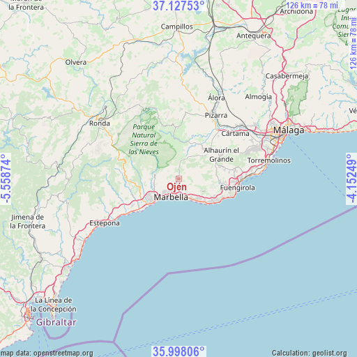
Ojén GPS coordinates[2]
36° 33' 53.496" North, 4° 51' 20.196" West
| Map corner | latitude | longitude |
|---|---|---|
| Upper-left | 37.12753°, | -5.55874° |
| Center: | 36.56486°, | -4.85561° |
| Lower-right: | 35.99806°, | -4.15249° |
| Map W x H: | 125.6×125.6 km | = 78×78mi |
| max Lat: | 43.74134° ⇑97.9% North |
| Ojén: | 36.56486° |
| min Lat: | ⇓2.1% South 27.64134° |
| min Long | Ojén | max Long |
| -18.00367° | -4.85561° | 4.2899° |
| W 29.5%⇐ | ⇒70.5% E |
Elevation
Elevation of Ojén is 330 m = 1083 ft, and this is 268 m = 879 ft below average elevation for this country.
| Max E: |
1682 m = 5518 ft | 73.1% |
| Avg. | 598 m = 1962 ft | |
| Ojén | 330 m = 1083 ft | |
Min E: |
0 m = 0 ft | 26.9% |
See also: Spain elevation on elevation.city.
Geographical zone
Ojén is located in North temperate zone (between Tropic of Cancer and the Arctic Circle). Distance of this Northern Tropic circle is 1459.7 km =907 mi to South.| Distance of | km | miles | from Ojén |
|---|---|---|---|
| North Pole | 5941.4 | 3691.8 | to North |
| Arctic Circle | 3335.5 | 2072.6 | to North |
| Tropic Cancer | 1459.7 | 907 | to South |
| Equator | 4065.6 | 2526.2 | to South |


Nearby cities:
15 places around Ojén: (largest is in red/bold)
• Alhaurín el Grande
17.4 km =10.8 mi,  59°
59°
• Alozaina
18.1 km =11.2 mi,  359°
359°
• Benahavís
17.6 km =10.9 mi,  254°
254°
• Casarabonela
24.6 km =15.3 mi,  2°
2°
• Coín
13.8 km =8.6 mi,  40°
40°
• Fuengirola
20.8 km =12.9 mi,  97°
97°
• Guaro
10.3 km =6.4 mi,  10°
10°
• Igualeja
24.9 km =15.5 mi,  287°
287°
• Istán
8.6 km =5.3 mi,  283°
283°
• Marbella
6.1 km =3.8 mi,  206°
206°
• Mijas
19.8 km =12.3 mi,  80°
80°
• Monda
7.6 km =4.7 mi,  16°
16°
• San Pedro de Alcántara
14.8 km =9.2 mi,  234°
234°
• Tolox
14.3 km =8.9 mi,  342°
342°
• Yunquera
19.5 km =12.1 mi, 342°
Sources, notices
• [Note1] Compared only with cities in Spain existing in our database
• [Src1] Map data: © OpenStreetMap contributors (CC-BY-SA)
• [Src2] Other city data from geonames.org with taken over terms of usage.
• [Src3] Geographical zone / Annual Mean Temperature by Robert A. Rohde @ Wikipedia
