Mijas geodata
Mijas (Andalusia) is a seat of a third-order administrative division; located in Spain in Europe/Madrid (GMT+2) time zone. With population of 73,787 people, there are 126 cities with bigger population in this country. Compared to other cities in Spain, 97.8% of cities are located further ↑North; 67.8% of cities are located further →East and 67.9% of cities have higher elevation than Mijas. Note1


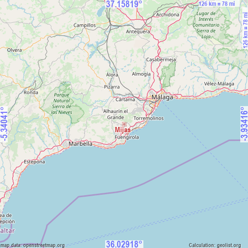
Mijas GPS coordinates[2]
36° 35' 44.7" North, 4° 38' 14.208" West
| Map corner | latitude | longitude |
|---|---|---|
| Upper-left | 37.15819°, | -5.34041° |
| Center: | 36.59575°, | -4.63728° |
| Lower-right: | 36.02918°, | -3.93416° |
| Map W x H: | 125.5×125.5 km | = 78×78mi |
| max Lat: | 43.74134° ⇑97.8% North |
| Mijas: | 36.59575° |
| min Lat: | ⇓2.2% South 27.64134° |
| min Long | Mijas | max Long |
| -18.00367° | -4.63728° | 4.2899° |
| W 32.2%⇐ | ⇒67.8% E |
Elevation
Elevation of Mijas is 418 m = 1371 ft, and this is 180 m = 591 ft below average elevation for this country.
| Max E: |
1682 m = 5518 ft | 67.9% |
| Avg. | 598 m = 1962 ft | |
| Mijas | 418 m = 1371 ft | |
Min E: |
0 m = 0 ft | 32.1% |
See also: Mijas elevation on elevation.city.
Geographical zone
Mijas is located in North temperate zone (between Tropic of Cancer and the Arctic Circle). Distance of this Northern Tropic circle is 1463.1 km =909.1 mi to South.| Distance of | km | miles | from Mijas |
|---|---|---|---|
| North Pole | 5938 | 3689.7 | to North |
| Arctic Circle | 3332.1 | 2070.5 | to North |
| Tropic Cancer | 1463.1 | 909.1 | to South |
| Equator | 4069.1 | 2528.4 | to South |


Nearby cities:
15 places around Mijas: (largest is in red/bold)
• Alhaurín de la Torre
10.2 km =6.3 mi,  41°
41°
• Alhaurín el Grande
6.9 km =4.3 mi,  319°
319°
• Alozaina
24.5 km =15.2 mi,  306°
306°
• Benalmádena
5.8 km =3.6 mi,  89°
89°
• Coín
12.8 km =8 mi,  303°
303°
• Cártama
12.8 km =8 mi,  1°
1°
• Estación de Cártama
15.4 km =9.6 mi,  6°
6°
• Fuengirola
6.3 km =3.9 mi,  169°
169°
• Guaro
18.8 km =11.7 mi,  290°
290°
• Marbella
23.9 km =14.9 mi,  248°
248°
• Monda
17.8 km =11.1 mi,  282°
282°
• Málaga
23.8 km =14.8 mi,  54°
54°
• Ojén
19.8 km =12.3 mi,  260°
260°
• Pizarra
19.9 km =12.4 mi,  341°
341°
• Torremolinos
12.6 km =7.8 mi,  77°
77°
Sources, notices
• [Note1] Compared only with cities in Spain existing in our database
• [Src1] Map data: © OpenStreetMap contributors (CC-BY-SA)
• [Src2] Other city data from geonames.org with taken over terms of usage.
• [Src3] Geographical zone / Annual Mean Temperature by Robert A. Rohde @ Wikipedia
