Fuengirola geodata
Fuengirola (Andalusia) is a seat of a third-order administrative division; located in Spain in Europe/Madrid (GMT+2) time zone. With population of 71,482 people, there are 129 cities with bigger population in this country. Compared to other cities in Spain, 98% of cities are located further ↑North; 67.6% of cities are located further →East and 97.6% of cities have higher elevation than Fuengirola. Note1


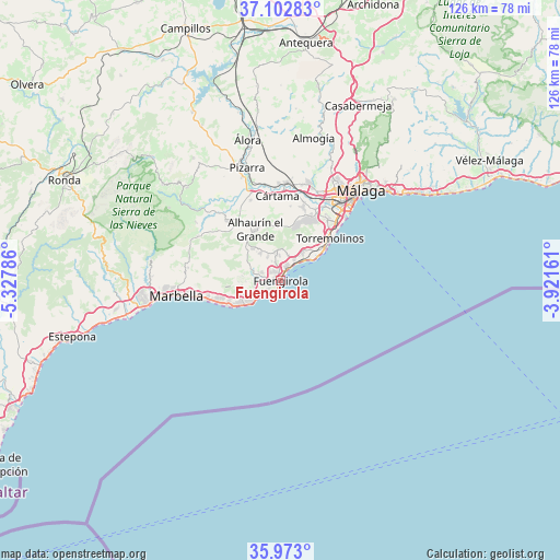
Fuengirola GPS coordinates[2]
36° 32' 23.928" North, 4° 37' 29.028" West
| Map corner | latitude | longitude |
|---|---|---|
| Upper-left | 37.10283°, | -5.32786° |
| Center: | 36.53998°, | -4.62473° |
| Lower-right: | 35.973°, | -3.92161° |
| Map W x H: | 125.6×125.6 km | = 78×78mi |
| max Lat: | 43.74134° ⇑98% North |
| Fuengirola: | 36.53998° |
| min Lat: | ⇓2% South 27.64134° |
| min Long | Fuengirola | max Long |
| -18.00367° | -4.62473° | 4.2899° |
| W 32.4%⇐ | ⇒67.6% E |
Elevation
Elevation of Fuengirola is 13 m = 43 ft, and this is 585 m = 1919 ft below average elevation for this country.
| Max E: |
1682 m = 5518 ft | 97.6% |
| Avg. | 598 m = 1962 ft | |
| Fuengirola | 13 m = 43 ft | |
Min E: |
0 m = 0 ft | 2.4% |
See also: Fuengirola elevation on elevation.city.
Geographical zone
Fuengirola is located in North temperate zone (between Tropic of Cancer and the Arctic Circle). Distance of this Northern Tropic circle is 1456.9 km =905.3 mi to South.| Distance of | km | miles | from Fuengirola |
|---|---|---|---|
| North Pole | 5944.2 | 3693.6 | to North |
| Arctic Circle | 3338.3 | 2074.3 | to North |
| Tropic Cancer | 1456.9 | 905.3 | to South |
| Equator | 4062.9 | 2524.6 | to South |


Nearby cities:
15 places around Fuengirola: (largest is in red/bold)
• Alhaurín de la Torre
14.9 km =9.3 mi,  22°
22°
• Alhaurín el Grande
12.7 km =7.9 mi,  334°
334°
• Benalmádena
7.8 km =4.8 mi,  36°
36°
• Coín
17.7 km =11 mi,  318°
318°
• Cártama
19 km =11.8 mi,  357°
357°
• Estación de Cártama
21.5 km =13.4 mi,  1°
1°
• Guaro
22.7 km =14.1 mi,  304°
304°
• Istán
29.4 km =18.3 mi,  279°
279°
• Marbella
23.5 km =14.6 mi,  263°
263°
• Mijas
6.3 km =3.9 mi,  349°
349°
• Monda
21 km =13 mi, 298°
• Málaga
27.1 km =16.8 mi, 42°
• Ojén
20.8 km =12.9 mi, 277°
• Pizarra
26.2 km =16.3 mi,  343°
343°
• Torremolinos
14.3 km =8.9 mi,  51°
51°
Sources, notices
• [Note1] Compared only with cities in Spain existing in our database
• [Src1] Map data: © OpenStreetMap contributors (CC-BY-SA)
• [Src2] Other city data from geonames.org with taken over terms of usage.
• [Src3] Geographical zone / Annual Mean Temperature by Robert A. Rohde @ Wikipedia
