Alfacar geodata
Alfacar (Andalusia) is a seat of a third-order administrative division; located in Spain in Europe/Madrid (GMT+2) time zone. With population of 4,949 people, there are 1320 cities with bigger population in this country. Compared to other cities in Spain, 93.5% of cities are located further ↑North; 53.1% of cities are located further →East and 83.1% of cities have lower elevation than Alfacar. Note1


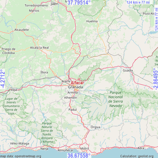
Alfacar GPS coordinates[2]
37° 14' 14.784" North, 3° 34' 5.052" West
| Map corner | latitude | longitude |
|---|---|---|
| Upper-left | 37.79514°, | -4.2712° |
| Center: | 37.23744°, | -3.56807° |
| Lower-right: | 36.67558°, | -2.86495° |
| Map W x H: | 124.5×124.5 km | = 77.4×77.4mi |
| max Lat: | 43.74134° ⇑93.5% North |
| Alfacar: | 37.23744° |
| min Lat: | ⇓6.5% South 27.64134° |
| min Long | Alfacar | max Long |
| -18.00367° | -3.56807° | 4.2899° |
| W 46.9%⇐ | ⇒53.1% E |
Elevation
Elevation of Alfacar is 929 m = 3048 ft, and this is 331 m = 1086 ft above average elevation for this country.
| Max E: |
1682 m = 5518 ft | 16.9% |
| Alfacar | 929 m 3048 ft | |
| Avg. | 598 m = 1962 ft | |
Min E: |
0 m = 0 ft | 83.1% |
See also: Spain elevation on elevation.city.
Geographical zone
Alfacar is located in North temperate zone (between Tropic of Cancer and the Arctic Circle). Distance of this Northern Tropic circle is 1534.5 km =953.5 mi to South.| Distance of | km | miles | from Alfacar |
|---|---|---|---|
| North Pole | 5866.6 | 3645.3 | to North |
| Arctic Circle | 3260.8 | 2026.2 | to North |
| Tropic Cancer | 1534.5 | 953.5 | to South |
| Equator | 4140.4 | 2572.7 | to South |


Nearby cities:
15 places around Alfacar: (largest is in red/bold)
• Albolote
7.7 km =4.8 mi,  264°
264°
• Beas de Granada
8 km =5 mi,  105°
105°
• Calicasas
5.5 km =3.4 mi,  313°
313°
• Cenes de la Vega
9.1 km =5.7 mi,  161°
161°
• Dúdar
9.4 km =5.8 mi,  127°
127°
• Granada
6.5 km =4 mi,  211°
211°
• Güevéjar
3.4 km =2.1 mi, 311°
• Huétor Santillán
4.9 km =3 mi, 111°
• Jun
3 km =1.9 mi,  231°
231°
• Maracena
6.8 km =4.2 mi,  240°
240°
• Nívar
2.6 km =1.6 mi,  340°
340°
• Peligros
5.4 km =3.4 mi, 263°
• Pinos Genil
10.1 km =6.3 mi,  144°
144°
• Pulianas
3.9 km =2.4 mi,  245°
245°
• Víznar
1.4 km =0.9 mi,  117°
117°
Sources, notices
• [Note1] Compared only with cities in Spain existing in our database
• [Src1] Map data: © OpenStreetMap contributors (CC-BY-SA)
• [Src2] Other city data from geonames.org with taken over terms of usage.
• [Src3] Geographical zone / Annual Mean Temperature by Robert A. Rohde @ Wikipedia
