Maracena geodata
Maracena (Andalusia) is a seat of a third-order administrative division; located in Spain in Europe/Madrid (GMT+2) time zone. With population of 20,815 people, there are 461 cities with bigger population in this country. Compared to other cities in Spain, 93.9% of cities are located further ↑North; 54.3% of cities are located further →East and 50.3% of cities have lower elevation than Maracena. Note1


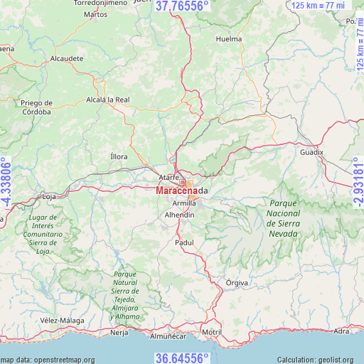
Maracena GPS coordinates[2]
37° 12' 27.504" North, 3° 38' 5.748" West
| Map corner | latitude | longitude |
|---|---|---|
| Upper-left | 37.76556°, | -4.33806° |
| Center: | 37.20764°, | -3.63493° |
| Lower-right: | 36.64556°, | -2.93181° |
| Map W x H: | 124.5×124.5 km | = 77.4×77.4mi |
| max Lat: | 43.74134° ⇑93.9% North |
| Maracena: | 37.20764° |
| min Lat: | ⇓6.1% South 27.64134° |
| min Long | Maracena | max Long |
| -18.00367° | -3.63493° | 4.2899° |
| W 45.7%⇐ | ⇒54.3% E |
Elevation
Elevation of Maracena is 662 m = 2172 ft, and this is 64 m = 210 ft above average elevation for this country.
| Max E: |
1682 m = 5518 ft | 49.7% |
| Maracena | 662 m 2172 ft | |
| Avg. | 598 m = 1962 ft | |
Min E: |
0 m = 0 ft | 50.3% |
See also: Spain elevation on elevation.city.
Geographical zone
Maracena is located in North temperate zone (between Tropic of Cancer and the Arctic Circle). Distance of this Northern Tropic circle is 1531.2 km =951.4 mi to South.| Distance of | km | miles | from Maracena |
|---|---|---|---|
| North Pole | 5870 | 3647.4 | to North |
| Arctic Circle | 3264.1 | 2028.2 | to North |
| Tropic Cancer | 1531.2 | 951.4 | to South |
| Equator | 4137.1 | 2570.7 | to South |


Nearby cities:
15 places around Maracena: (largest is in red/bold)
• Albolote
3.1 km =1.9 mi,  325°
325°
• Alfacar
6.8 km =4.2 mi,  60°
60°
• Armilla
7.1 km =4.4 mi,  173°
173°
• Atarfe
5 km =3.1 mi,  292°
292°
• Calicasas
7.3 km =4.5 mi,  15°
15°
• Churriana de la Vega
7 km =4.3 mi,  188°
188°
• Cúllar-Vega
6.8 km =4.2 mi,  207°
207°
• Granada
3.3 km =2.1 mi,  130°
130°
• Güevéjar
6.5 km =4 mi,  31°
31°
• Jun
3.9 km =2.4 mi,  67°
67°
• Nívar
7.6 km =4.7 mi,  41°
41°
• Peligros
2.8 km =1.7 mi,  10°
10°
• Pulianas
2.9 km =1.8 mi,  54°
54°
• Santafé
7.7 km =4.8 mi,  254°
254°
• Víznar
7.7 km =4.8 mi, 69°
Sources, notices
• [Note1] Compared only with cities in Spain existing in our database
• [Src1] Map data: © OpenStreetMap contributors (CC-BY-SA)
• [Src2] Other city data from geonames.org with taken over terms of usage.
• [Src3] Geographical zone / Annual Mean Temperature by Robert A. Rohde @ Wikipedia
