Albolote geodata
Albolote (Andalusia) is a seat of a third-order administrative division; located in Spain in Europe/Madrid (GMT+2) time zone. With population of 17,089 people, there are 553 cities with bigger population in this country. Compared to other cities in Spain, 93.7% of cities are located further ↑North; 54.6% of cities are located further →East and 50.4% of cities have higher elevation than Albolote. Note1


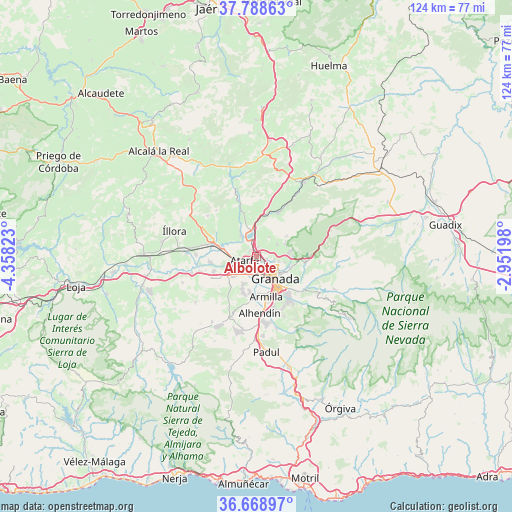
Albolote GPS coordinates[2]
37° 13' 51.168" North, 3° 39' 18.36" West
| Map corner | latitude | longitude |
|---|---|---|
| Upper-left | 37.78863°, | -4.35823° |
| Center: | 37.23088°, | -3.6551° |
| Lower-right: | 36.66897°, | -2.95198° |
| Map W x H: | 124.5×124.5 km | = 77.4×77.4mi |
| max Lat: | 43.74134° ⇑93.7% North |
| Albolote: | 37.23088° |
| min Lat: | ⇓6.3% South 27.64134° |
| min Long | Albolote | max Long |
| -18.00367° | -3.6551° | 4.2899° |
| W 45.4%⇐ | ⇒54.6% E |
Elevation
Elevation of Albolote is 654 m = 2146 ft, and this is 56 m = 184 ft above average elevation for this country.
| Max E: |
1682 m = 5518 ft | 50.4% |
| Albolote | 654 m 2146 ft | |
| Avg. | 598 m = 1962 ft | |
Min E: |
0 m = 0 ft | 49.6% |
See also: Spain elevation on elevation.city.
Geographical zone
Albolote is located in North temperate zone (between Tropic of Cancer and the Arctic Circle). Distance of this Northern Tropic circle is 1533.8 km =953.1 mi to South.| Distance of | km | miles | from Albolote |
|---|---|---|---|
| North Pole | 5867.4 | 3645.8 | to North |
| Arctic Circle | 3261.5 | 2026.6 | to North |
| Tropic Cancer | 1533.8 | 953.1 | to South |
| Equator | 4139.7 | 2572.3 | to South |


Nearby cities:
15 places around Albolote: (largest is in red/bold)
• Alfacar
7.7 km =4.8 mi,  84°
84°
• Atarfe
2.9 km =1.8 mi,  256°
256°
• Calicasas
5.8 km =3.6 mi,  39°
39°
• Churriana de la Vega
9.6 km =6 mi,  175°
175°
• Cúllar-Vega
8.7 km =5.4 mi,  189°
189°
• Granada
6.4 km =4 mi,  137°
137°
• Güevéjar
5.9 km =3.7 mi,  60°
60°
• Jun
5.5 km =3.4 mi,  101°
101°
• Maracena
3.1 km =1.9 mi,  145°
145°
• Nívar
7.5 km =4.7 mi,  65°
65°
• Peligros
2.3 km =1.4 mi,  86°
86°
• Pinos Puente
8.7 km =5.4 mi,  285°
285°
• Pulianas
4.2 km =2.6 mi, 101°
• Santafé
7.4 km =4.6 mi,  230°
230°
• Víznar
9 km =5.6 mi, 89°
Sources, notices
• [Note1] Compared only with cities in Spain existing in our database
• [Src1] Map data: © OpenStreetMap contributors (CC-BY-SA)
• [Src2] Other city data from geonames.org with taken over terms of usage.
• [Src3] Geographical zone / Annual Mean Temperature by Robert A. Rohde @ Wikipedia
