Aldea del Cano geodata
Aldea del Cano (Extremadura) is a seat of a third-order administrative division; located in Spain in Europe/Madrid (GMT+2) time zone. With population of 746 people, there are 3313 cities with bigger population in this country. Compared to other cities in Spain, 78.6% of cities are located further ↑North; 89.6% of cities are located further →East and 69.3% of cities have higher elevation than Aldea del Cano. Note1
Administrative division(s):
- Level 1: Extremadura
- Level 2: Provincia de Cáceres
- Level 3: Aldea del Cano


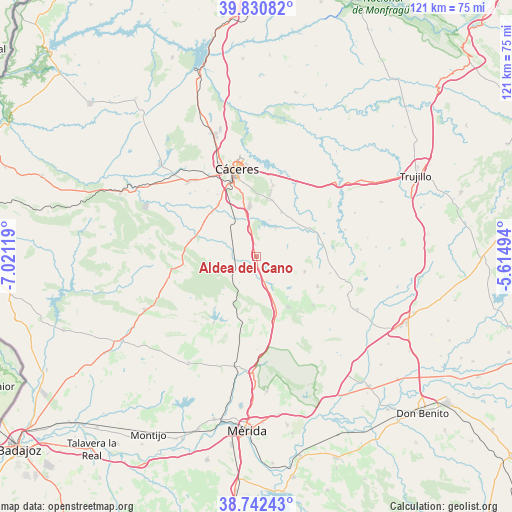
Aldea del Cano GPS coordinates[2]
39° 17' 19.464" North, 6° 19' 5.016" West
| Map corner | latitude | longitude |
|---|---|---|
| Upper-left | 39.83082°, | -7.02119° |
| Center: | 39.28874°, | -6.31806° |
| Lower-right: | 38.74243°, | -5.61494° |
| Map W x H: | 121×121 km | = 75.2×75.2mi |
| max Lat: | 43.74134° ⇑78.6% North |
| Aldea del Cano: | 39.28874° |
| min Lat: | ⇓21.4% South 27.64134° |
| min Long | Aldea del Cano | max Long |
| -18.00367° | -6.31806° | 4.2899° |
| W 10.4%⇐ | ⇒89.6% E |
Elevation
Elevation of Aldea del Cano is 395 m = 1296 ft, and this is 203 m = 666 ft below average elevation for this country.
| Max E: |
1682 m = 5518 ft | 69.3% |
| Avg. | 598 m = 1962 ft | |
| Aldea del Cano | 395 m = 1296 ft | |
Min E: |
0 m = 0 ft | 30.7% |
See also: Spain elevation on elevation.city.
Geographical zone
Aldea del Cano is located in North temperate zone (between Tropic of Cancer and the Arctic Circle). Distance of this Northern Tropic circle is 1762.6 km =1095.2 mi to South.| Distance of | km | miles | from Aldea del Cano |
|---|---|---|---|
| North Pole | 5638.6 | 3503.7 | to North |
| Arctic Circle | 3032.7 | 1884.4 | to North |
| Tropic Cancer | 1762.6 | 1095.2 | to South |
| Equator | 4368.5 | 2714.5 | to South |


Nearby cities:
15 places around Aldea del Cano: (largest is in red/bold)
• Albalá
12 km =7.5 mi,  107°
107°
• Alcuéscar
14.2 km =8.8 mi,  147°
147°
• Arroyomolinos de Montánchez
17.7 km =11 mi,  130°
130°
• Benquerencia
20.2 km =12.6 mi,  83°
83°
• Carmonita
15 km =9.3 mi,  186°
186°
• Casas de Don Antonio
6.3 km =3.9 mi,  158°
158°
• Cordobilla de Lácara
18.7 km =11.6 mi,  212°
212°
• Montánchez
16.2 km =10.1 mi,  115°
115°
• Sierra de Fuentes
17.3 km =10.7 mi,  13°
13°
• Torre de Santa María
17.8 km =11.1 mi,  102°
102°
• Torremocha
14 km =8.7 mi,  63°
63°
• Torreorgaz
12 km =7.5 mi,  29°
29°
• Torrequemada
12.1 km =7.5 mi,  44°
44°
• Valdefuentes
17 km =10.6 mi, 95°
• Valdesalor
10.2 km =6.3 mi,  345°
345°
Sources, notices
• [Note1] Compared only with cities in Spain existing in our database
• [Src1] Map data: © OpenStreetMap contributors (CC-BY-SA)
• [Src2] Other city data from geonames.org with taken over terms of usage.
• [Src3] Geographical zone / Annual Mean Temperature by Robert A. Rohde @ Wikipedia
