Torremocha geodata
Torremocha (Extremadura) is a seat of a third-order administrative division; located in Spain in Europe/Madrid (GMT+2) time zone. With population of 1,135 people, there are 2787 cities with bigger population in this country. Compared to other cities in Spain, 78.3% of cities are located further ↑North; 88.2% of cities are located further →East and 66.1% of cities have higher elevation than Torremocha. Note1


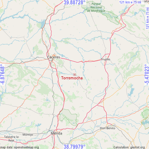
Torremocha GPS coordinates[2]
39° 20' 44.34" North, 6° 10' 24.06" West
| Map corner | latitude | longitude |
|---|---|---|
| Upper-left | 39.88728°, | -6.87648° |
| Center: | 39.34565°, | -6.17335° |
| Lower-right: | 38.79979°, | -5.47023° |
| Map W x H: | 120.9×120.9 km | = 75.1×75.1mi |
| max Lat: | 43.74134° ⇑78.3% North |
| Torremocha: | 39.34565° |
| min Lat: | ⇓21.7% South 27.64134° |
| min Long | Torremocha | max Long |
| -18.00367° | -6.17335° | 4.2899° |
| W 11.8%⇐ | ⇒88.2% E |
Elevation
Elevation of Torremocha is 445 m = 1460 ft, and this is 153 m = 502 ft below average elevation for this country.
| Max E: |
1682 m = 5518 ft | 66.1% |
| Avg. | 598 m = 1962 ft | |
| Torremocha | 445 m = 1460 ft | |
Min E: |
0 m = 0 ft | 33.9% |
See also: Spain elevation on elevation.city.
Geographical zone
Torremocha is located in North temperate zone (between Tropic of Cancer and the Arctic Circle). Distance of this Northern Tropic circle is 1768.9 km =1099.1 mi to South.| Distance of | km | miles | from Torremocha |
|---|---|---|---|
| North Pole | 5632.2 | 3499.7 | to North |
| Arctic Circle | 3026.3 | 1880.5 | to North |
| Tropic Cancer | 1768.9 | 1099.1 | to South |
| Equator | 4374.8 | 2718.4 | to South |


Nearby cities:
15 places around Torremocha: (largest is in red/bold)
• Albalá
10 km =6.2 mi,  185°
185°
• Aldea del Cano
14 km =8.7 mi,  243°
243°
• Benquerencia
8.6 km =5.3 mi,  117°
117°
• Botija
8.6 km =5.3 mi,  90°
90°
• Montánchez
13.5 km =8.4 mi,  171°
171°
• Plasenzuela
11.5 km =7.1 mi,  69°
69°
• Ruanes
13.9 km =8.6 mi,  98°
98°
• Salvatierra de Santiago
13 km =8.1 mi,  111°
111°
• Sierra de Fuentes
13.5 km =8.4 mi,  320°
320°
• Torre de Santa María
11.3 km =7 mi,  154°
154°
• Torreorgaz
7.8 km =4.8 mi,  302°
302°
• Torrequemada
4.7 km =2.9 mi, 299°
• Valdefuentes
9.1 km =5.7 mi, 150°
• Valdesalor
15.5 km =9.6 mi,  283°
283°
• Zarza de Montánchez
15.6 km =9.7 mi,  128°
128°
Sources, notices
• [Note1] Compared only with cities in Spain existing in our database
• [Src1] Map data: © OpenStreetMap contributors (CC-BY-SA)
• [Src2] Other city data from geonames.org with taken over terms of usage.
• [Src3] Geographical zone / Annual Mean Temperature by Robert A. Rohde @ Wikipedia
