Cordobilla de Lácara geodata
Cordobilla de Lácara (Extremadura) is a seat of a third-order administrative division; located in Spain in Europe/Madrid (GMT+2) time zone. With population of 1,062 people, there are 2862 cities with bigger population in this country. Compared to other cities in Spain, 79.8% of cities are located further ↑North; 90.7% of cities are located further →East and 74.6% of cities have higher elevation than Cordobilla de Lácara. Note1
Administrative division(s):
- Level 1: Extremadura
- Level 2: Provincia de Badajoz
- Level 3: Cordobilla de Lácara


Cordobilla de Lácara GPS coordinates[2]
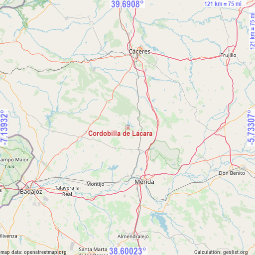
39° 8' 51.468" North, 6° 26' 10.284" West
| Map corner | latitude | longitude |
|---|---|---|
| Upper-left | 39.6908°, | -7.13932° |
| Center: | 39.14763°, | -6.43619° |
| Lower-right: | 38.60023°, | -5.73307° |
| Map W x H: | 121.3×121.3 km | = 75.4×75.4mi |
| max Lat: | 43.74134° ⇑79.8% North |
| Cordobilla de Lácara: | 39.14763° |
| min Lat: | ⇓20.2% South 27.64134° |
| min Long | Cordobilla de L | max Long |
| -18.00367° | -6.43619° | 4.2899° |
| W 9.3%⇐ | ⇒90.7% E |
Elevation
Elevation of Cordobilla de Lácara is 301 m = 988 ft, and this is 297 m = 974 ft below average elevation for this country.
| Max E: |
1682 m = 5518 ft | 74.6% |
| Avg. | 598 m = 1962 ft | |
| Cordobilla de Lácara | 301 m = 988 ft | |
Min E: |
0 m = 0 ft | 25.4% |
See also: Spain elevation on elevation.city.
Geographical zone
Cordobilla de Lácara is located in North temperate zone (between Tropic of Cancer and the Arctic Circle). Distance of this Northern Tropic circle is 1746.9 km =1085.5 mi to South.| Distance of | km | miles | from Cordobilla de Lácara |
|---|---|---|---|
| North Pole | 5654.3 | 3513.4 | to North |
| Arctic Circle | 3048.4 | 1894.2 | to North |
| Tropic Cancer | 1746.9 | 1085.5 | to South |
| Equator | 4352.8 | 2704.7 | to South |


Nearby cities:
15 places around Cordobilla de Lácara: (largest is in red/bold)
• Albalá
24.7 km =15.3 mi,  60°
60°
• Alcuéscar
18.2 km =11.3 mi,  78°
78°
• Aldea del Cano
18.7 km =11.6 mi,  32°
32°
• Aljucén
14.6 km =9.1 mi,  141°
141°
• Arroyomolinos de Montánchez
24 km =14.9 mi, 79°
• Carmonita
8.4 km =5.2 mi, 84°
• Casas de Don Antonio
15.9 km =9.9 mi,  51°
51°
• Esparragalejo
22.7 km =14.1 mi,  179°
179°
• La Garrovilla
25.6 km =15.9 mi,  188°
188°
• La Nava de Santiago
11.1 km =6.9 mi,  212°
212°
• La Roca de la Sierra
22.2 km =13.8 mi,  259°
259°
• Mirandilla
20.6 km =12.8 mi, 141°
• Montánchez
26.2 km =16.3 mi,  70°
70°
• Puebla de Obando
16.8 km =10.4 mi,  280°
280°
• Trujillanos
26.6 km =16.5 mi, 144°
Sources, notices
• [Note1] Compared only with cities in Spain existing in our database
• [Src1] Map data: © OpenStreetMap contributors (CC-BY-SA)
• [Src2] Other city data from geonames.org with taken over terms of usage.
• [Src3] Geographical zone / Annual Mean Temperature by Robert A. Rohde @ Wikipedia
