Alcázar de San Juan geodata
Alcázar de San Juan (Castille-La Mancha) is a seat of a third-order administrative division; located in Spain in Europe/Madrid (GMT+2) time zone. With population of 30,675 people, there are 296 cities with bigger population in this country. Compared to other cities in Spain, 77.9% of cities are located further ↑North; 51.5% of cities are located further ←West and 50.9% of cities have higher elevation than Alcázar de San Juan. Note1
Administrative division(s):
- Level 1: Castille-La Mancha
- Level 2: Provincia de Ciudad Real
- Level 3: Alcázar de San Juan


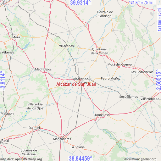
Alcázar de San Juan GPS coordinates[2]
39° 23' 24.396" North, 3° 12' 29.772" West
| Map corner | latitude | longitude |
|---|---|---|
| Upper-left | 39.9314°, | -3.9114° |
| Center: | 39.39011°, | -3.20827° |
| Lower-right: | 38.84459°, | -2.50515° |
| Map W x H: | 120.8×120.8 km | = 75.1×75.1mi |
| max Lat: | 43.74134° ⇑77.9% North |
| Alcázar de San Juan: | 39.39011° |
| min Lat: | ⇓22.1% South 27.64134° |
| min Long | Alcázar de San | max Long |
| -18.00367° | -3.20827° | 4.2899° |
| W 51.5%⇐ | ⇒48.5% E |
Elevation
Elevation of Alcázar de San Juan is 649 m = 2129 ft, and this is 51 m = 167 ft above average elevation for this country.
| Max E: |
1682 m = 5518 ft | 50.9% |
| Alcázar de San Juan | 649 m 2129 ft | |
| Avg. | 598 m = 1962 ft | |
Min E: |
0 m = 0 ft | 49.1% |
See also: Spain elevation on elevation.city.
Geographical zone
Alcázar de San Juan is located in North temperate zone (between Tropic of Cancer and the Arctic Circle). Distance of this Northern Tropic circle is 1773.9 km =1102.3 mi to South.| Distance of | km | miles | from Alcázar de San Juan |
|---|---|---|---|
| North Pole | 5627.3 | 3496.6 | to North |
| Arctic Circle | 3021.4 | 1877.4 | to North |
| Tropic Cancer | 1773.9 | 1102.3 | to South |
| Equator | 4379.8 | 2721.5 | to South |


Nearby cities:
15 places around Alcázar de San Juan: (largest is in red/bold)
• Campo de Criptana
7.3 km =4.5 mi,  77°
77°
• Camuñas
21.6 km =13.4 mi,  280°
280°
• El Toboso
22.7 km =14.1 mi,  52°
52°
• Herencia
13.1 km =8.1 mi,  258°
258°
• La Puebla de Almoradiel
24.4 km =15.2 mi,  18°
18°
• Madridejos
29.1 km =18.1 mi,  287°
287°
• Miguel Esteban
18.8 km =11.7 mi,  37°
37°
• Pedro Muñoz
22.5 km =14 mi,  86°
86°
• Puerto Lápice
24.6 km =15.3 mi,  252°
252°
• Quero
13.9 km =8.6 mi,  345°
345°
• Quintanar de la Orden
26.8 km =16.7 mi,  32°
32°
• Villa de Don Fadrique
25 km =15.5 mi,  357°
357°
• Villacañas
28.3 km =17.6 mi,  336°
336°
• Villafranca de los Caballeros
13.8 km =8.6 mi, 287°
• Villarta de San Juan
25.1 km =15.6 mi,  227°
227°
Sources, notices
• [Note1] Compared only with cities in Spain existing in our database
• [Src1] Map data: © OpenStreetMap contributors (CC-BY-SA)
• [Src2] Other city data from geonames.org with taken over terms of usage.
• [Src3] Geographical zone / Annual Mean Temperature by Robert A. Rohde @ Wikipedia
