Puerto Lápice geodata
Puerto Lápice (Castille-La Mancha) is a populated place; located in Spain in Europe/Madrid (GMT+2) time zone. With population of 1,001 people, there are 2937 cities with bigger population in this country. Compared to other cities in Spain, 78.5% of cities are located further ↑North; 51.8% of cities are located further →East and 51.9% of cities have lower elevation than Puerto Lápice. Note1
Administrative division(s):
- Level 1: Castille-La Mancha
- Level 2: Province of Toledo
- Level 3: Madridejos


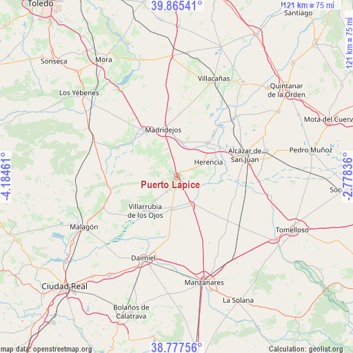
Puerto Lápice GPS coordinates[2]
39° 19' 24.96" North, 3° 28' 53.328" West
| Map corner | latitude | longitude |
|---|---|---|
| Upper-left | 39.86541°, | -4.18461° |
| Center: | 39.3236°, | -3.48148° |
| Lower-right: | 38.77756°, | -2.77836° |
| Map W x H: | 121×121 km | = 75.2×75.2mi |
| max Lat: | 43.74134° ⇑78.5% North |
| Puerto Lápice: | 39.3236° |
| min Lat: | ⇓21.5% South 27.64134° |
| min Long | Puerto Lápice | max Long |
| -18.00367° | -3.48148° | 4.2899° |
| W 48.2%⇐ | ⇒51.8% E |
Elevation
Elevation of Puerto Lápice is 678 m = 2224 ft, and this is 80 m = 262 ft above average elevation for this country.
| Max E: |
1682 m = 5518 ft | 48.1% |
| Puerto Lápice | 678 m 2224 ft | |
| Avg. | 598 m = 1962 ft | |
Min E: |
0 m = 0 ft | 51.9% |
See also: Spain elevation on elevation.city.
Geographical zone
Puerto Lápice is located in North temperate zone (between Tropic of Cancer and the Arctic Circle). Distance of this Northern Tropic circle is 1766.5 km =1097.7 mi to South.| Distance of | km | miles | from Puerto Lápice |
|---|---|---|---|
| North Pole | 5634.7 | 3501.2 | to North |
| Arctic Circle | 3028.8 | 1882 | to North |
| Tropic Cancer | 1766.5 | 1097.7 | to South |
| Equator | 4372.4 | 2716.9 | to South |


Nearby cities:
15 places around Puerto Lápice: (largest is in red/bold)
• Alcázar de San Juan
24.6 km =15.3 mi,  72°
72°
• Arenas de San Juan
11.8 km =7.3 mi,  188°
188°
• Camuñas
11.7 km =7.3 mi,  11°
11°
• Consuegra
18.9 km =11.7 mi,  324°
324°
• Daimiel
30.4 km =18.9 mi,  202°
202°
• Fuente el Fresno
27.4 km =17 mi,  247°
247°
• Herencia
11.7 km =7.3 mi, 66°
• Las Labores
6.3 km =3.9 mi,  210°
210°
• Llanos del Caudillo
25.5 km =15.8 mi,  153°
153°
• Madridejos
16.7 km =10.4 mi,  344°
344°
• Quero
29 km =18 mi,  43°
43°
• Urda
22.3 km =13.9 mi,  296°
296°
• Villafranca de los Caballeros
15.6 km =9.7 mi, 41°
• Villarrubia de los Ojos
15.8 km =9.8 mi,  223°
223°
• Villarta de San Juan
10.8 km =6.7 mi, 152°
Sources, notices
• [Note1] Compared only with cities in Spain existing in our database
• [Src1] Map data: © OpenStreetMap contributors (CC-BY-SA)
• [Src2] Other city data from geonames.org with taken over terms of usage.
• [Src3] Geographical zone / Annual Mean Temperature by Robert A. Rohde @ Wikipedia
