Quero geodata
Quero (Castille-La Mancha) is a seat of a third-order administrative division; located in Spain in Europe/Madrid (GMT+2) time zone. With population of 1,240 people, there are 2688 cities with bigger population in this country. Compared to other cities in Spain, 76.8% of cities are located further ↑North; 51% of cities are located further ←West and 50.4% of cities have higher elevation than Quero. Note1


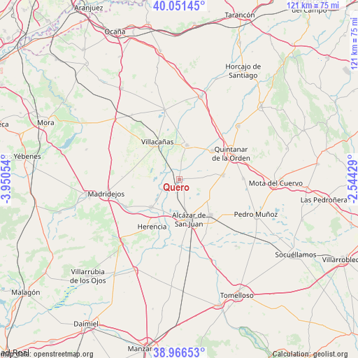
Quero GPS coordinates[2]
39° 30' 39.996" North, 3° 14' 50.676" West
| Map corner | latitude | longitude |
|---|---|---|
| Upper-left | 40.05145°, | -3.95054° |
| Center: | 39.51111°, | -3.24741° |
| Lower-right: | 38.96653°, | -2.54429° |
| Map W x H: | 120.6×120.6 km | = 74.9×74.9mi |
| max Lat: | 43.74134° ⇑76.8% North |
| Quero: | 39.51111° |
| min Lat: | ⇓23.2% South 27.64134° |
| min Long | Quero | max Long |
| -18.00367° | -3.24741° | 4.2899° |
| W 51%⇐ | ⇒49% E |
Elevation
Elevation of Quero is 654 m = 2146 ft, and this is 56 m = 184 ft above average elevation for this country.
| Max E: |
1682 m = 5518 ft | 50.4% |
| Quero | 654 m 2146 ft | |
| Avg. | 598 m = 1962 ft | |
Min E: |
0 m = 0 ft | 49.6% |
See also: Spain elevation on elevation.city.
Geographical zone
Quero is located in North temperate zone (between Tropic of Cancer and the Arctic Circle). Distance of this Northern Tropic circle is 1787.3 km =1110.6 mi to South.| Distance of | km | miles | from Quero |
|---|---|---|---|
| North Pole | 5613.8 | 3488.3 | to North |
| Arctic Circle | 3008 | 1869.1 | to North |
| Tropic Cancer | 1787.3 | 1110.6 | to South |
| Equator | 4393.2 | 2729.8 | to South |


Nearby cities:
15 places around Quero: (largest is in red/bold)
• Alcázar de San Juan
13.9 km =8.6 mi,  165°
165°
• Campo de Criptana
15.8 km =9.8 mi,  138°
138°
• Camuñas
20.1 km =12.5 mi,  242°
242°
• El Toboso
21.5 km =13.4 mi,  89°
89°
• Herencia
18.7 km =11.6 mi,  210°
210°
• La Puebla de Almoradiel
14.8 km =9.2 mi,  48°
48°
• Lillo
24.1 km =15 mi,  347°
347°
• Madridejos
24.9 km =15.5 mi,  258°
258°
• Miguel Esteban
14.8 km =9.2 mi,  84°
84°
• Quintanar de la Orden
19.9 km =12.4 mi,  62°
62°
• Romeral
27 km =16.8 mi,  323°
323°
• Villa de Don Fadrique
11.8 km =7.3 mi,  11°
11°
• Villacañas
14.7 km =9.1 mi,  328°
328°
• Villafranca de los Caballeros
13.4 km =8.3 mi,  226°
226°
• Villanueva de Alcardete
26.9 km =16.7 mi, 47°
Sources, notices
• [Note1] Compared only with cities in Spain existing in our database
• [Src1] Map data: © OpenStreetMap contributors (CC-BY-SA)
• [Src2] Other city data from geonames.org with taken over terms of usage.
• [Src3] Geographical zone / Annual Mean Temperature by Robert A. Rohde @ Wikipedia
