Villacañas geodata
Villacañas (Castille-La Mancha) is a seat of a third-order administrative division; located in Spain in Europe/Madrid (GMT+2) time zone. With population of 10,645 people, there are 820 cities with bigger population in this country. Compared to other cities in Spain, 75.4% of cities are located further ↑North; 50% of cities are located further ←West and 51.8% of cities have lower elevation than Villacañas. Note1
Administrative division(s):
- Level 1: Castille-La Mancha
- Level 2: Province of Toledo
- Level 3: Villacañas


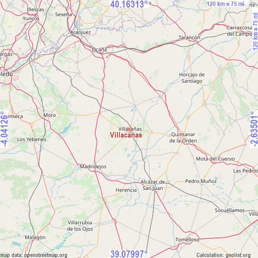
Villacañas GPS coordinates[2]
39° 37' 25.212" North, 3° 20' 17.268" West
| Map corner | latitude | longitude |
|---|---|---|
| Upper-left | 40.16313°, | -4.04126° |
| Center: | 39.62367°, | -3.33813° |
| Lower-right: | 39.07997°, | -2.63501° |
| Map W x H: | 120.4×120.4 km | = 74.8×74.8mi |
| max Lat: | 43.74134° ⇑75.4% North |
| Villacañas: | 39.62367° |
| min Lat: | ⇓24.6% South 27.64134° |
| min Long | Villacañas | max Long |
| -18.00367° | -3.33813° | 4.2899° |
| W 50%⇐ | ⇒50% E |
Elevation
Elevation of Villacañas is 677 m = 2221 ft, and this is 79 m = 259 ft above average elevation for this country.
| Max E: |
1682 m = 5518 ft | 48.2% |
| Villacañas | 677 m 2221 ft | |
| Avg. | 598 m = 1962 ft | |
Min E: |
0 m = 0 ft | 51.8% |
See also: Spain elevation on elevation.city.
Geographical zone
Villacañas is located in North temperate zone (between Tropic of Cancer and the Arctic Circle). Distance of this Northern Tropic circle is 1799.8 km =1118.3 mi to South.| Distance of | km | miles | from Villacañas |
|---|---|---|---|
| North Pole | 5601.3 | 3480.5 | to North |
| Arctic Circle | 2995.4 | 1861.3 | to North |
| Tropic Cancer | 1799.8 | 1118.3 | to South |
| Equator | 4405.7 | 2737.6 | to South |


Nearby cities:
15 places around Villacañas: (largest is in red/bold)
• Camuñas
24.1 km =15 mi,  204°
204°
• Corral de Almaguer
21.2 km =13.2 mi,  44°
44°
• La Guardia
21.7 km =13.5 mi,  327°
327°
• La Puebla de Almoradiel
19.1 km =11.9 mi,  98°
98°
• Lillo
11.4 km =7.1 mi,  13°
13°
• Madridejos
24 km =14.9 mi,  223°
223°
• Miguel Esteban
25 km =15.5 mi,  116°
116°
• Quero
14.7 km =9.1 mi,  148°
148°
• Quintanar de la Orden
25.6 km =15.9 mi, 97°
• Romeral
12.4 km =7.7 mi,  318°
318°
• Tembleque
16.3 km =10.1 mi,  299°
299°
• Turleque
23.8 km =14.8 mi,  264°
264°
• Villa de Don Fadrique
10.2 km =6.3 mi, 95°
• Villafranca de los Caballeros
21.8 km =13.5 mi,  185°
185°
• Villanueva de Alcardete
28.3 km =17.6 mi,  78°
78°
Sources, notices
• [Note1] Compared only with cities in Spain existing in our database
• [Src1] Map data: © OpenStreetMap contributors (CC-BY-SA)
• [Src2] Other city data from geonames.org with taken over terms of usage.
• [Src3] Geographical zone / Annual Mean Temperature by Robert A. Rohde @ Wikipedia
