Alcalalí geodata
Alcalalí (Valencia) is a seat of a third-order administrative division; located in Spain in Europe/Madrid (GMT+2) time zone. With population of 1,299 people, there are 2646 cities with bigger population in this country. Compared to other cities in Spain, 83.7% of cities are located further ↑North; 86.8% of cities are located further ←West and 79.3% of cities have higher elevation than Alcalalí. Note1


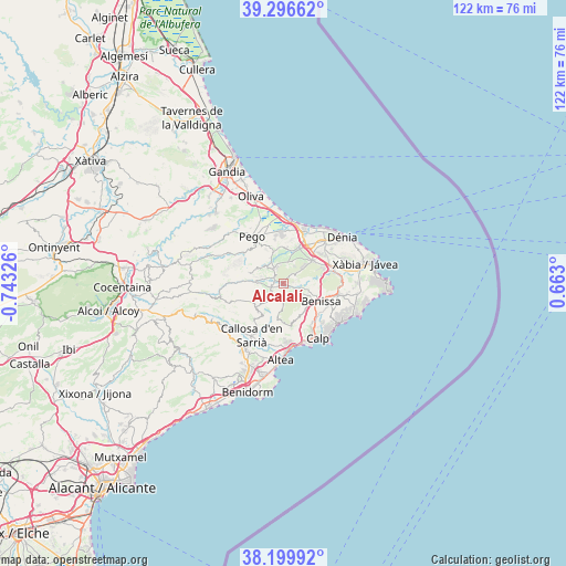
Alcalalí GPS coordinates[2]
38° 45' 1.368" North, 0° 2' 24.468" West
| Map corner | latitude | longitude |
|---|---|---|
| Upper-left | 39.29662°, | -0.74326° |
| Center: | 38.75038°, | -0.04013° |
| Lower-right: | 38.19992°, | 0.663° |
| Map W x H: | 121.9×121.9 km | = 75.7×75.7mi |
| max Lat: | 43.74134° ⇑83.7% North |
| Alcalalí: | 38.75038° |
| min Lat: | ⇓16.3% South 27.64134° |
| min Long | Alcalalí | max Long |
| -18.00367° | -0.04013° | 4.2899° |
| W 86.8%⇐ | ⇒13.2% E |
Elevation
Elevation of Alcalalí is 233 m = 764 ft, and this is 365 m = 1198 ft below average elevation for this country.
| Max E: |
1682 m = 5518 ft | 79.3% |
| Avg. | 598 m = 1962 ft | |
| Alcalalí | 233 m = 764 ft | |
Min E: |
0 m = 0 ft | 20.7% |
See also: Spain elevation on elevation.city.
Geographical zone
Alcalalí is located in North temperate zone (between Tropic of Cancer and the Arctic Circle). Distance of this Northern Tropic circle is 1702.7 km =1058 mi to South.| Distance of | km | miles | from Alcalalí |
|---|---|---|---|
| North Pole | 5698.4 | 3540.8 | to North |
| Arctic Circle | 3092.5 | 1921.6 | to North |
| Tropic Cancer | 1702.7 | 1058 | to South |
| Equator | 4308.6 | 2677.2 | to South |


Nearby cities:
15 places around Alcalalí: (largest is in red/bold)
• Benichembla
6 km =3.7 mi,  274°
274°
• Benidoleig
4.8 km =3 mi,  10°
10°
• Benimeli
8.1 km =5 mi,  358°
358°
• Benissa
8.6 km =5.3 mi,  117°
117°
• Jalón
2.7 km =1.7 mi,  113°
113°
• Murla
3.8 km =2.4 mi,  286°
286°
• Orba
3.9 km =2.4 mi,  329°
329°
• Parcent
2.2 km =1.4 mi,  254°
254°
• Pedreguer
8 km =5 mi,  53°
53°
• Ráfol de Almunia
7.9 km =4.9 mi,  352°
352°
• Sagra
7.1 km =4.4 mi,  341°
341°
• Sanet y Negrals
7.7 km =4.8 mi,  3°
3°
• Senija
7.5 km =4.7 mi, 109°
• Tormos
6.3 km =3.9 mi, 334°
• Tárbena
8.2 km =5.1 mi,  220°
220°
Sources, notices
• [Note1] Compared only with cities in Spain existing in our database
• [Src1] Map data: © OpenStreetMap contributors (CC-BY-SA)
• [Src2] Other city data from geonames.org with taken over terms of usage.
• [Src3] Geographical zone / Annual Mean Temperature by Robert A. Rohde @ Wikipedia
