Senija geodata
Senija (Valencia) is a seat of a third-order administrative division; located in Spain in Europe/Madrid (GMT+2) time zone. With population of 588 people, there are 3644 cities with bigger population in this country. Compared to other cities in Spain, 83.9% of cities are located further ↑North; 87.2% of cities are located further ←West and 79% of cities have higher elevation than Senija. Note1


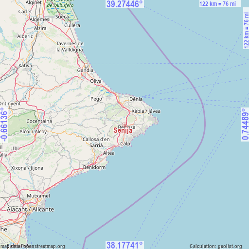
Senija GPS coordinates[2]
38° 43' 40.944" North, 0° 2' 30.336" East
| Map corner | latitude | longitude |
|---|---|---|
| Upper-left | 39.27446°, | -0.66136° |
| Center: | 38.72804°, | 0.04176° |
| Lower-right: | 38.17741°, | 0.74489° |
| Map W x H: | 122×122 km | = 75.8×75.8mi |
| max Lat: | 43.74134° ⇑83.9% North |
| Senija: | 38.72804° |
| min Lat: | ⇓16.1% South 27.64134° |
| min Long | Senija | max Long |
| -18.00367° | 0.04176° | 4.2899° |
| W 87.2%⇐ | ⇒12.8% E |
Elevation
Elevation of Senija is 238 m = 781 ft, and this is 360 m = 1181 ft below average elevation for this country.
| Max E: |
1682 m = 5518 ft | 79% |
| Avg. | 598 m = 1962 ft | |
| Senija | 238 m = 781 ft | |
Min E: |
0 m = 0 ft | 21% |
See also: Spain elevation on elevation.city.
Geographical zone
Senija is located in North temperate zone (between Tropic of Cancer and the Arctic Circle). Distance of this Northern Tropic circle is 1700.2 km =1056.5 mi to South.| Distance of | km | miles | from Senija |
|---|---|---|---|
| North Pole | 5700.9 | 3542.4 | to North |
| Arctic Circle | 3095 | 1923.1 | to North |
| Tropic Cancer | 1700.2 | 1056.5 | to South |
| Equator | 4306.2 | 2675.7 | to South |


Nearby cities:
15 places around Senija: (largest is in red/bold)
• Alcalalí
7.5 km =4.7 mi,  289°
289°
• Beniarbeig
11.2 km =7 mi,  340°
340°
• Benidoleig
9.5 km =5.9 mi,  319°
319°
• Benissa
1.6 km =1 mi,  158°
158°
• Benitachell
8.8 km =5.5 mi,  86°
86°
• Calp
9.3 km =5.8 mi,  178°
178°
• Gata de Gorgos
6.4 km =4 mi,  36°
36°
• Jalón
4.8 km =3 mi, 286°
• Moraira
9.2 km =5.7 mi,  118°
118°
• Murla
11.3 km =7 mi, 288°
• Ondara
11.3 km =7 mi,  349°
349°
• Orba
10.8 km =6.7 mi,  302°
302°
• Parcent
9.4 km =5.8 mi,  281°
281°
• Pedreguer
7.3 km =4.5 mi, 354°
• Teulada
5.4 km =3.4 mi, 88°
Sources, notices
• [Note1] Compared only with cities in Spain existing in our database
• [Src1] Map data: © OpenStreetMap contributors (CC-BY-SA)
• [Src2] Other city data from geonames.org with taken over terms of usage.
• [Src3] Geographical zone / Annual Mean Temperature by Robert A. Rohde @ Wikipedia
