Alcalá del Júcar geodata
Alcalá del Júcar (Castille-La Mancha) is a seat of a third-order administrative division; located in Spain in Europe/Madrid (GMT+2) time zone. With population of 1,397 people, there are 2547 cities with bigger population in this country. Compared to other cities in Spain, 79.5% of cities are located further ↑North; 73.6% of cities are located further ←West and 56.7% of cities have higher elevation than Alcalá del Júcar. Note1
Administrative division(s):
- Level 1: Castille-La Mancha
- Level 2: Provincia de Albacete
- Level 3: Alcalá del Júcar


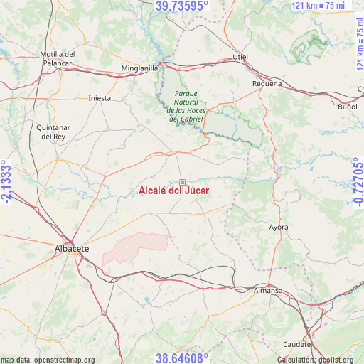
Alcalá del Júcar GPS coordinates[2]
39° 11' 35.268" North, 1° 25' 48.612" West
| Map corner | latitude | longitude |
|---|---|---|
| Upper-left | 39.73595°, | -2.1333° |
| Center: | 39.19313°, | -1.43017° |
| Lower-right: | 38.64608°, | -0.72705° |
| Map W x H: | 121.2×121.2 km | = 75.3×75.3mi |
| max Lat: | 43.74134° ⇑79.5% North |
| Alcalá del Júcar: | 39.19313° |
| min Lat: | ⇓20.5% South 27.64134° |
| min Long | Alcalá del Jú | max Long |
| -18.00367° | -1.43017° | 4.2899° |
| W 73.6%⇐ | ⇒26.4% E |
Elevation
Elevation of Alcalá del Júcar is 570 m = 1870 ft, and this is 28 m = 92 ft below average elevation for this country.
| Max E: |
1682 m = 5518 ft | 56.7% |
| Avg. | 598 m = 1962 ft | |
| Alcalá del Júcar | 570 m = 1870 ft | |
Min E: |
0 m = 0 ft | 43.3% |
See also: Spain elevation on elevation.city.
Geographical zone
Alcalá del Júcar is located in North temperate zone (between Tropic of Cancer and the Arctic Circle). Distance of this Northern Tropic circle is 1751.9 km =1088.6 mi to South.| Distance of | km | miles | from Alcalá del Júcar |
|---|---|---|---|
| North Pole | 5649.2 | 3510.2 | to North |
| Arctic Circle | 3043.3 | 1891 | to North |
| Tropic Cancer | 1751.9 | 1088.6 | to South |
| Equator | 4357.9 | 2707.9 | to South |


Nearby cities:
15 places around Alcalá del Júcar: (largest is in red/bold)
• Abengibre
9.3 km =5.8 mi,  286°
286°
• Alatoz
12.4 km =7.7 mi,  151°
151°
• Alborea
10.8 km =6.7 mi,  21°
21°
• Balsa de Ves
21.4 km =13.3 mi,  67°
67°
• Carcelén
14.6 km =9.1 mi,  134°
134°
• Casas Ibáñez
10.5 km =6.5 mi,  342°
342°
• Casas de Juan Núñez
15 km =9.3 mi,  227°
227°
• Casas de Ves
10.5 km =6.5 mi,  52°
52°
• Fuentealbilla
13.2 km =8.2 mi,  308°
308°
• Golosalvo
18.1 km =11.2 mi,  284°
284°
• Jorquera
8 km =5 mi,  248°
248°
• Pozo Lorente
14.6 km =9.1 mi,  207°
207°
• Villa de Ves
17 km =10.6 mi,  87°
87°
• Villatoya
19.2 km =11.9 mi,  35°
35°
• Villavaliente
7.8 km =4.8 mi,  197°
197°
Sources, notices
• [Note1] Compared only with cities in Spain existing in our database
• [Src1] Map data: © OpenStreetMap contributors (CC-BY-SA)
• [Src2] Other city data from geonames.org with taken over terms of usage.
• [Src3] Geographical zone / Annual Mean Temperature by Robert A. Rohde @ Wikipedia
