Alatoz geodata
Alatoz (Castille-La Mancha) is a seat of a third-order administrative division; located in Spain in Europe/Madrid (GMT+2) time zone. With population of 585 people, there are 3650 cities with bigger population in this country. Compared to other cities in Spain, 80.2% of cities are located further ↑North; 74.2% of cities are located further ←West and 76% of cities have lower elevation than Alatoz. Note1
Administrative division(s):
- Level 1: Castille-La Mancha
- Level 2: Provincia de Albacete
- Level 3: Alatoz


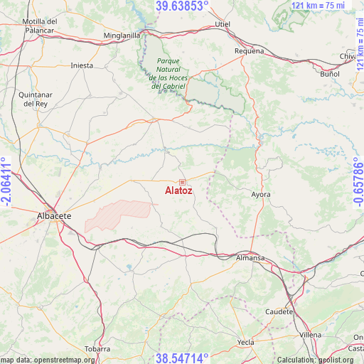
Alatoz GPS coordinates[2]
39° 5' 41.82" North, 1° 21' 39.528" West
| Map corner | latitude | longitude |
|---|---|---|
| Upper-left | 39.63853°, | -2.06411° |
| Center: | 39.09495°, | -1.36098° |
| Lower-right: | 38.54714°, | -0.65786° |
| Map W x H: | 121.4×121.4 km | = 75.4×75.4mi |
| max Lat: | 43.74134° ⇑80.2% North |
| Alatoz: | 39.09495° |
| min Lat: | ⇓19.8% South 27.64134° |
| min Long | Alatoz | max Long |
| -18.00367° | -1.36098° | 4.2899° |
| W 74.2%⇐ | ⇒25.8% E |
Elevation
Elevation of Alatoz is 860 m = 2822 ft, and this is 262 m = 860 ft above average elevation for this country.
| Max E: |
1682 m = 5518 ft | 24% |
| Alatoz | 860 m 2822 ft | |
| Avg. | 598 m = 1962 ft | |
Min E: |
0 m = 0 ft | 76% |
See also: Spain elevation on elevation.city.
Geographical zone
Alatoz is located in North temperate zone (between Tropic of Cancer and the Arctic Circle). Distance of this Northern Tropic circle is 1741 km =1081.8 mi to South.| Distance of | km | miles | from Alatoz |
|---|---|---|---|
| North Pole | 5660.1 | 3517 | to North |
| Arctic Circle | 3054.2 | 1897.8 | to North |
| Tropic Cancer | 1741 | 1081.8 | to South |
| Equator | 4347 | 2701.1 | to South |


Nearby cities:
15 places around Alatoz: (largest is in red/bold)
• Abengibre
20.1 km =12.5 mi,  312°
312°
• Alborea
21 km =13 mi,  354°
354°
• Alcalá del Júcar
12.4 km =7.7 mi,  331°
331°
• Alpera
18.9 km =11.7 mi,  143°
143°
• Balsa de Ves
23.6 km =14.7 mi,  36°
36°
• Carcelén
4.6 km =2.9 mi,  80°
80°
• Casas Ibáñez
22.8 km =14.2 mi,  336°
336°
• Casas de Juan Núñez
17 km =10.6 mi,  272°
272°
• Casas de Ves
17.4 km =10.8 mi,  7°
7°
• Higueruela
16.2 km =10.1 mi,  206°
206°
• Hoya-Gonzalo
22.8 km =14.2 mi,  227°
227°
• Jorquera
15.6 km =9.7 mi,  300°
300°
• Pozo Lorente
12.8 km =8 mi,  260°
260°
• Villa de Ves
16 km =9.9 mi, 43°
• Villavaliente
9 km =5.6 mi,  292°
292°
Sources, notices
• [Note1] Compared only with cities in Spain existing in our database
• [Src1] Map data: © OpenStreetMap contributors (CC-BY-SA)
• [Src2] Other city data from geonames.org with taken over terms of usage.
• [Src3] Geographical zone / Annual Mean Temperature by Robert A. Rohde @ Wikipedia
