Albalat dels Tarongers geodata
Albalat dels Tarongers (Valencia) is a seat of a third-order administrative division; located in Spain in Europe/Madrid (GMT+2) time zone. With population of 799 people, there are 3210 cities with bigger population in this country. Compared to other cities in Spain, 74.5% of cities are located further ↑North; 84.2% of cities are located further ←West and 88.1% of cities have higher elevation than Albalat dels Tarongers. Note1
Administrative division(s):
- Level 1: Valencia
- Level 2: Província de València
- Level 3: Albalat dels Tarongers
Current local time in Albalat dels Tarongers:
10:49 PM, ThursdayDifference from your time zone: hours


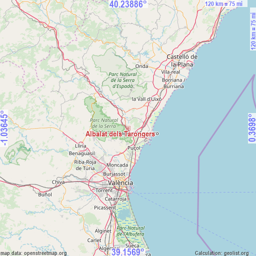
Albalat dels Tarongers GPS coordinates[2]
39° 42' 0" North, 0° 19' 59.988" West
| Map corner | latitude | longitude |
|---|---|---|
| Upper-left | 40.23886°, | -1.03645° |
| Center: | 39.7°, | -0.33333° |
| Lower-right: | 39.1569°, | 0.3698° |
| Map W x H: | 120.3×120.3 km | = 74.8×74.8mi |
| max Lat: | 43.74134° ⇑74.5% North |
| Albalat dels Tarongers: | 39.7° |
| min Lat: | ⇓25.5% South 27.64134° |
| min Long | Albalat dels Ta | max Long |
| -18.00367° | -0.33333° | 4.2899° |
| W 84.2%⇐ | ⇒15.8% E |
Elevation
Elevation of Albalat dels Tarongers is 93 m = 305 ft, and this is 505 m = 1657 ft below average elevation for this country.
| Max E: |
1682 m = 5518 ft | 88.1% |
| Avg. | 598 m = 1962 ft | |
| Albalat dels Tarongers | 93 m = 305 ft | |
Min E: |
0 m = 0 ft | 11.9% |
See also: Spain elevation on elevation.city.
Geographical zone
Albalat dels Tarongers is located in North temperate zone (between Tropic of Cancer and the Arctic Circle). Distance of this Northern Tropic circle is 1808.3 km =1123.6 mi to South.| Distance of | km | miles | from Albalat dels Tarongers |
|---|---|---|---|
| North Pole | 5592.8 | 3475.2 | to North |
| Arctic Circle | 2986.9 | 1856 | to North |
| Tropic Cancer | 1808.3 | 1123.6 | to South |
| Equator | 4414.2 | 2742.9 | to South |


Nearby cities:
15 places around Albalat dels Tarongers: (largest is in red/bold)
• Alfara de Algimia
7.5 km =4.7 mi,  349°
349°
• Algimia de Alfara
6.2 km =3.9 mi,  332°
332°
• Benavites
8 km =5 mi,  62°
62°
• Benifairó de les Valls
6.8 km =4.2 mi, 56°
• Estivella
2.3 km =1.4 mi,  322°
322°
• Faura
7.4 km =4.6 mi,  75°
75°
• Gilet
2.3 km =1.4 mi,  142°
142°
• Náquera
9 km =5.6 mi,  232°
232°
• Petrés
3.4 km =2.1 mi,  123°
123°
• Puçol
9.7 km =6 mi,  162°
162°
• Quart de les Valls
6.8 km =4.2 mi, 56°
• Quartell
7.2 km =4.5 mi,  54°
54°
• Sagunto
6 km =3.7 mi,  108°
108°
• Segart
3.4 km =2.1 mi,  236°
236°
• Serra
8.8 km =5.5 mi,  257°
257°
Sources, notices
• [Note1] Compared only with cities in Spain existing in our database
• [Src1] Map data: © OpenStreetMap contributors (CC-BY-SA)
• [Src2] Other city data from geonames.org with taken over terms of usage.
• [Src3] Geographical zone / Annual Mean Temperature by Robert A. Rohde @ Wikipedia
