Náquera geodata
Náquera (Valencia) is a seat of a third-order administrative division; located in Spain in Europe/Madrid (GMT+2) time zone. With population of 3,770 people, there are 1525 cities with bigger population in this country. Compared to other cities in Spain, 75.1% of cities are located further ↑North; 82.9% of cities are located further ←West and 80% of cities have higher elevation than Náquera. Note1


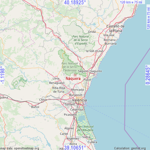
Náquera GPS coordinates[2]
39° 39' 0" North, 0° 25' 0.012" West
| Map corner | latitude | longitude |
|---|---|---|
| Upper-left | 40.18925°, | -1.1198° |
| Center: | 39.65°, | -0.41667° |
| Lower-right: | 39.10651°, | 0.28645° |
| Map W x H: | 120.4×120.4 km | = 74.8×74.8mi |
| max Lat: | 43.74134° ⇑75.1% North |
| Náquera: | 39.65° |
| min Lat: | ⇓24.9% South 27.64134° |
| min Long | Náquera | max Long |
| -18.00367° | -0.41667° | 4.2899° |
| W 82.9%⇐ | ⇒17.1% E |
Elevation
Elevation of Náquera is 220 m = 722 ft, and this is 378 m = 1240 ft below average elevation for this country.
| Max E: |
1682 m = 5518 ft | 80% |
| Avg. | 598 m = 1962 ft | |
| Náquera | 220 m = 722 ft | |
Min E: |
0 m = 0 ft | 20% |
See also: Spain elevation on elevation.city.
Geographical zone
Náquera is located in North temperate zone (between Tropic of Cancer and the Arctic Circle). Distance of this Northern Tropic circle is 1802.7 km =1120.1 mi to South.| Distance of | km | miles | from Náquera |
|---|---|---|---|
| North Pole | 5598.4 | 3478.7 | to North |
| Arctic Circle | 2992.5 | 1859.5 | to North |
| Tropic Cancer | 1802.7 | 1120.1 | to South |
| Equator | 4408.7 | 2739.4 | to South |


Nearby cities:
15 places around Náquera: (largest is in red/bold)
• Albalat dels Tarongers
9 km =5.6 mi,  52°
52°
• Alfara del Patriarca
11.5 km =7.1 mi,  165°
165°
• Algimia de Alfara
11.9 km =7.4 mi,  21°
21°
• Bétera
7.6 km =4.7 mi,  210°
210°
• Estivella
9.4 km =5.8 mi,  37°
37°
• Gilet
9.3 km =5.8 mi,  66°
66°
• Massamagrell
11.7 km =7.3 mi,  142°
142°
• Moncada
11.8 km =7.3 mi, 171°
• Museros
10.9 km =6.8 mi,  148°
148°
• Olocau
11.4 km =7.1 mi,  299°
299°
• Petrés
10.7 km =6.6 mi, 69°
• Puig
11.9 km =7.4 mi,  125°
125°
• Puçol
10.7 km =6.6 mi,  110°
110°
• Segart
5.7 km =3.5 mi, 49°
• Serra
4 km =2.5 mi,  338°
338°
Sources, notices
• [Note1] Compared only with cities in Spain existing in our database
• [Src1] Map data: © OpenStreetMap contributors (CC-BY-SA)
• [Src2] Other city data from geonames.org with taken over terms of usage.
• [Src3] Geographical zone / Annual Mean Temperature by Robert A. Rohde @ Wikipedia
