Adamuz geodata
Adamuz (Andalusia) is a seat of a third-order administrative division; located in Spain in Europe/Madrid (GMT+2) time zone. With population of 4,383 people, there are 1400 cities with bigger population in this country. Compared to other cities in Spain, 88.4% of cities are located further ↑North; 66.5% of cities are located further →East and 79.1% of cities have higher elevation than Adamuz. Note1


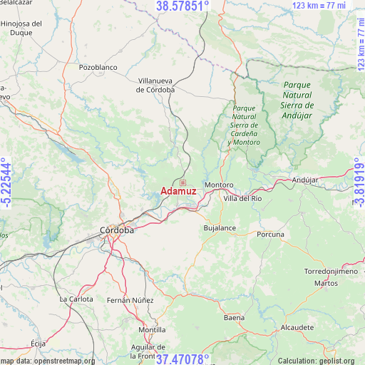
Adamuz GPS coordinates[2]
38° 1' 36.264" North, 4° 31' 20.316" West
| Map corner | latitude | longitude |
|---|---|---|
| Upper-left | 38.57851°, | -5.22544° |
| Center: | 38.02674°, | -4.52231° |
| Lower-right: | 37.47078°, | -3.81919° |
| Map W x H: | 123.2×123.2 km | = 76.6×76.6mi |
| max Lat: | 43.74134° ⇑88.4% North |
| Adamuz: | 38.02674° |
| min Lat: | ⇓11.6% South 27.64134° |
| min Long | Adamuz | max Long |
| -18.00367° | -4.52231° | 4.2899° |
| W 33.5%⇐ | ⇒66.5% E |
Elevation
Elevation of Adamuz is 237 m = 778 ft, and this is 361 m = 1184 ft below average elevation for this country.
| Max E: |
1682 m = 5518 ft | 79.1% |
| Avg. | 598 m = 1962 ft | |
| Adamuz | 237 m = 778 ft | |
Min E: |
0 m = 0 ft | 20.9% |
See also: Spain elevation on elevation.city.
Geographical zone
Adamuz is located in North temperate zone (between Tropic of Cancer and the Arctic Circle). Distance of this Northern Tropic circle is 1622.3 km =1008.1 mi to South.| Distance of | km | miles | from Adamuz |
|---|---|---|---|
| North Pole | 5778.9 | 3590.8 | to North |
| Arctic Circle | 3173 | 1971.6 | to North |
| Tropic Cancer | 1622.3 | 1008.1 | to South |
| Equator | 4228.2 | 2627.3 | to South |


Nearby cities:
15 places around Adamuz: (largest is in red/bold)
• Bujalance
19.2 km =11.9 mi,  139°
139°
• Cardeña
32.2 km =20 mi,  32°
32°
• Cañete de las Torres
25.2 km =15.7 mi,  134°
134°
• Córdoba
26.6 km =16.5 mi,  235°
235°
• El Carpio
9.8 km =6.1 mi,  166°
166°
• Lopera
28.4 km =17.6 mi,  108°
108°
• Marmolejo
30.9 km =19.2 mi,  86°
86°
• Montoro
12.2 km =7.6 mi, 91°
• Obejo
27 km =16.8 mi,  295°
295°
• Pedro Abad
8.9 km =5.5 mi, 138°
• Porcuna
34.3 km =21.3 mi,  120°
120°
• Villa del Río
21 km =13 mi,  104°
104°
• Villafranca de Córdoba
7.4 km =4.6 mi,  195°
195°
• Villaharta
35.1 km =21.8 mi,  289°
289°
• Villanueva de Córdoba
34.2 km =21.3 mi,  344°
344°
Sources, notices
• [Note1] Compared only with cities in Spain existing in our database
• [Src1] Map data: © OpenStreetMap contributors (CC-BY-SA)
• [Src2] Other city data from geonames.org with taken over terms of usage.
• [Src3] Geographical zone / Annual Mean Temperature by Robert A. Rohde @ Wikipedia
