Villaharta geodata
Villaharta (Andalusia) is a seat of a third-order administrative division; located in Spain in Europe/Madrid (GMT+2) time zone. With population of 606 people, there are 3601 cities with bigger population in this country. Compared to other cities in Spain, 87.6% of cities are located further ↑North; 71.1% of cities are located further →East and 59.3% of cities have higher elevation than Villaharta. Note1


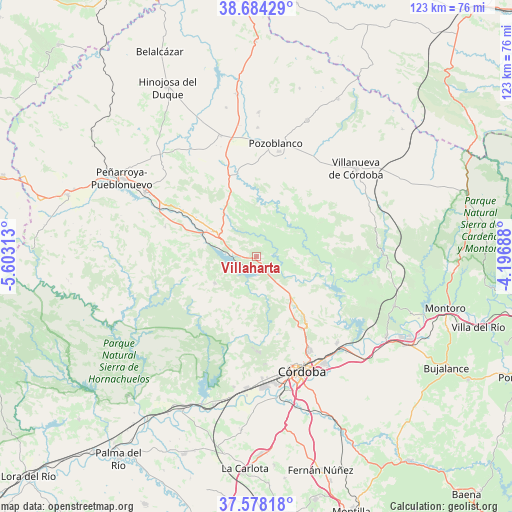
Villaharta GPS coordinates[2]
38° 7' 59.988" North, 4° 54' 0" West
| Map corner | latitude | longitude |
|---|---|---|
| Upper-left | 38.68429°, | -5.60313° |
| Center: | 38.13333°, | -4.9° |
| Lower-right: | 37.57818°, | -4.19688° |
| Map W x H: | 123×123 km | = 76.4×76.4mi |
| max Lat: | 43.74134° ⇑87.6% North |
| Villaharta: | 38.13333° |
| min Lat: | ⇓12.4% South 27.64134° |
| min Long | Villaharta | max Long |
| -18.00367° | -4.9° | 4.2899° |
| W 28.9%⇐ | ⇒71.1% E |
Elevation
Elevation of Villaharta is 536 m = 1759 ft, and this is 62 m = 203 ft below average elevation for this country.
| Max E: |
1682 m = 5518 ft | 59.3% |
| Avg. | 598 m = 1962 ft | |
| Villaharta | 536 m = 1759 ft | |
Min E: |
0 m = 0 ft | 40.7% |
See also: Spain elevation on elevation.city.
Geographical zone
Villaharta is located in North temperate zone (between Tropic of Cancer and the Arctic Circle). Distance of this Northern Tropic circle is 1634.1 km =1015.4 mi to South.| Distance of | km | miles | from Villaharta |
|---|---|---|---|
| North Pole | 5767 | 3583.4 | to North |
| Arctic Circle | 3161.1 | 1964.2 | to North |
| Tropic Cancer | 1634.1 | 1015.4 | to South |
| Equator | 4240 | 2634.6 | to South |


Nearby cities:
15 places around Villaharta: (largest is in red/bold)
• Adamuz
35.1 km =21.8 mi,  109°
109°
• Alcaracejos
28.4 km =17.6 mi,  348°
348°
• Añora
31.5 km =19.6 mi,  0°
0°
• Bélmez
30.1 km =18.7 mi,  299°
299°
• Córdoba
29.1 km =18.1 mi,  157°
157°
• Dos Torres
35.2 km =21.9 mi, 0°
• Espiel
12.6 km =7.8 mi,  306°
306°
• Fuente la Lancha
33.6 km =20.9 mi,  339°
339°
• Obejo
8.7 km =5.4 mi,  90°
90°
• Pedroche
34.9 km =21.7 mi,  19°
19°
• Pozoblanco
27.7 km =17.2 mi,  9°
9°
• Villanueva de Córdoba
31.7 km =19.7 mi,  48°
48°
• Villanueva del Duque
29.1 km =18.1 mi, 342°
• Villarrubia
31.5 km =19.6 mi,  180°
180°
• Villaviciosa de Córdoba
11.6 km =7.2 mi,  241°
241°
Sources, notices
• [Note1] Compared only with cities in Spain existing in our database
• [Src1] Map data: © OpenStreetMap contributors (CC-BY-SA)
• [Src2] Other city data from geonames.org with taken over terms of usage.
• [Src3] Geographical zone / Annual Mean Temperature by Robert A. Rohde @ Wikipedia
