Hondarribia geodata
Hondarribia (Basque Country) is a seat of a third-order administrative division; located in Spain in Europe/Madrid (GMT+2) time zone. With population of 16,458 people, there are 572 cities with bigger population in this country. Compared to other cities in Spain, 98.5% of cities are located further ↓South; 69.5% of cities are located further ←West and 94.5% of cities have higher elevation than Hondarribia. Note1


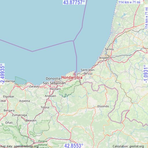
Hondarribia GPS coordinates[2]
43° 22' 6.924" North, 1° 47' 46.392" West
| Map corner | latitude | longitude |
|---|---|---|
| Upper-left | 43.87757°, | -2.49935° |
| Center: | 43.36859°, | -1.79622° |
| Lower-right: | 42.8553°, | -1.0931° |
| Map W x H: | 113.7×113.7 km | = 70.6×70.6mi |
| max Lat: | 43.74134° ⇑1.5% North |
| Hondarribia: | 43.36859° |
| min Lat: | ⇓98.5% South 27.64134° |
| min Long | Hondarribia | max Long |
| -18.00367° | -1.79622° | 4.2899° |
| W 69.5%⇐ | ⇒30.5% E |
Elevation
Elevation of Hondarribia is 27 m = 89 ft, and this is 571 m = 1873 ft below average elevation for this country.
| Max E: |
1682 m = 5518 ft | 94.5% |
| Avg. | 598 m = 1962 ft | |
| Hondarribia | 27 m = 89 ft | |
Min E: |
0 m = 0 ft | 5.5% |
See also: Spain elevation on elevation.city.
Geographical zone
Hondarribia is located in North temperate zone (between Tropic of Cancer and the Arctic Circle). Distance of this Northern Tropic circle is 2216.2 km =1377.1 mi to South.| Distance of | km | miles | from Hondarribia |
|---|---|---|---|
| North Pole | 5184.9 | 3221.7 | to North |
| Arctic Circle | 2579 | 1602.5 | to North |
| Tropic Cancer | 2216.2 | 1377.1 | to South |
| Equator | 4822.1 | 2996.3 | to South |


Nearby cities:
15 places around Hondarribia: (largest is in red/bold)
• Arano
20.4 km =12.7 mi,  203°
203°
• Arantza
20 km =12.4 mi,  163°
163°
• Astigarraga
15.5 km =9.6 mi,  231°
231°
• Bera
13.1 km =8.1 mi,  137°
137°
• Donostia / San Sebastián
15.7 km =9.8 mi,  246°
246°
• Errenteria
10.6 km =6.6 mi, 233°
• Etxalar
19.8 km =12.3 mi, 139°
• Hernani
18.5 km =11.5 mi, 231°
• Igantzi
17.7 km =11 mi,  154°
154°
• Irun
3.3 km =2.1 mi,  170°
170°
• Lasarte
21.4 km =13.3 mi,  238°
238°
• Lesaka
15.3 km =9.5 mi, 149°
• Lezo
9.7 km =6 mi, 237°
• Pasaia
11.6 km =7.2 mi, 245°
• Urnieta
20.7 km =12.9 mi, 229°
Sources, notices
• [Note1] Compared only with cities in Spain existing in our database
• [Src1] Map data: © OpenStreetMap contributors (CC-BY-SA)
• [Src2] Other city data from geonames.org with taken over terms of usage.
• [Src3] Geographical zone / Annual Mean Temperature by Robert A. Rohde @ Wikipedia
