Zucaina geodata
Zucaina (Valencia) is a seat of a third-order administrative division; located in Spain in Europe/Madrid (GMT+2) time zone. With population of 196 people, there are 5065 cities with bigger population in this country. Compared to other cities in Spain, 68.5% of cities are located further ↑North; 82.9% of cities are located further ←West and 55.6% of cities have lower elevation than Zucaina. Note1


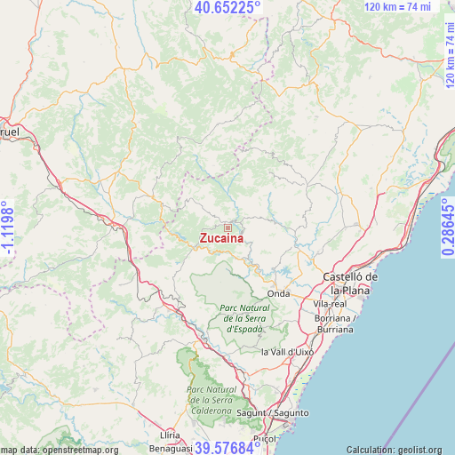
Zucaina GPS coordinates[2]
40° 7' 0.012" North, 0° 25' 0.012" West
| Map corner | latitude | longitude |
|---|---|---|
| Upper-left | 40.65225°, | -1.1198° |
| Center: | 40.11667°, | -0.41667° |
| Lower-right: | 39.57684°, | 0.28645° |
| Map W x H: | 119.6×119.6 km | = 74.3×74.3mi |
| max Lat: | 43.74134° ⇑68.5% North |
| Zucaina: | 40.11667° |
| min Lat: | ⇓31.5% South 27.64134° |
| min Long | Zucaina | max Long |
| -18.00367° | -0.41667° | 4.2899° |
| W 82.9%⇐ | ⇒17.1% E |
Elevation
Elevation of Zucaina is 713 m = 2339 ft, and this is 115 m = 377 ft above average elevation for this country.
| Max E: |
1682 m = 5518 ft | 44.4% |
| Zucaina | 713 m 2339 ft | |
| Avg. | 598 m = 1962 ft | |
Min E: |
0 m = 0 ft | 55.6% |
See also: Spain elevation on elevation.city.
Geographical zone
Zucaina is located in North temperate zone (between Tropic of Cancer and the Arctic Circle). Distance of this Northern Tropic circle is 1854.6 km =1152.4 mi to South.| Distance of | km | miles | from Zucaina |
|---|---|---|---|
| North Pole | 5546.5 | 3446.4 | to North |
| Arctic Circle | 2940.6 | 1827.2 | to North |
| Tropic Cancer | 1854.6 | 1152.4 | to South |
| Equator | 4460.6 | 2771.7 | to South |


Nearby cities:
15 places around Zucaina: (largest is in red/bold)
• Arañuel
7.9 km =4.9 mi,  225°
225°
• Argelita
9.3 km =5.8 mi,  142°
142°
• Ayódar
13.7 km =8.5 mi,  161°
161°
• Castillo de Villamalefa
3.4 km =2.1 mi,  56°
56°
• Cirat
7.9 km =4.9 mi,  200°
200°
• Cortes de Arenoso
13.3 km =8.3 mi,  306°
306°
• Espadilla
10.9 km =6.8 mi,  148°
148°
• Fanzara
14 km =8.7 mi, 142°
• Fuentes de Ayódar
9.3 km =5.8 mi,  180°
180°
• Lucena del Cid
11.5 km =7.1 mi,  80°
80°
• Ludiente
5.6 km =3.5 mi,  131°
131°
• Montanejos
10.2 km =6.3 mi,  236°
236°
• Toga
8.5 km =5.3 mi, 150°
• Torrechiva
7.5 km =4.7 mi,  169°
169°
• Villahermosa del Río
9.6 km =6 mi,  358°
358°
Sources, notices
• [Note1] Compared only with cities in Spain existing in our database
• [Src1] Map data: © OpenStreetMap contributors (CC-BY-SA)
• [Src2] Other city data from geonames.org with taken over terms of usage.
• [Src3] Geographical zone / Annual Mean Temperature by Robert A. Rohde @ Wikipedia
