Lucena del Cid geodata
Lucena del Cid (Valencia) is a seat of a third-order administrative division; located in Spain in Europe/Madrid (GMT+2) time zone. With population of 1,545 people, there are 2426 cities with bigger population in this country. Compared to other cities in Spain, 68.2% of cities are located further ↑North; 84.7% of cities are located further ←West and 53% of cities have higher elevation than Lucena del Cid. Note1
Administrative division(s):
- Level 1: Valencia
- Level 2: Província de Castelló
- Level 3: Lucena del Cid


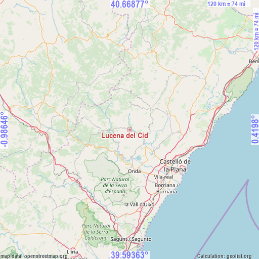
Lucena del Cid GPS coordinates[2]
40° 7' 59.988" North, 0° 16' 59.988" West
| Map corner | latitude | longitude |
|---|---|---|
| Upper-left | 40.66877°, | -0.98646° |
| Center: | 40.13333°, | -0.28333° |
| Lower-right: | 39.59363°, | 0.4198° |
| Map W x H: | 119.5×119.5 km | = 74.3×74.3mi |
| max Lat: | 43.74134° ⇑68.2% North |
| Lucena del Cid: | 40.13333° |
| min Lat: | ⇓31.8% South 27.64134° |
| min Long | Lucena del Cid | max Long |
| -18.00367° | -0.28333° | 4.2899° |
| W 84.7%⇐ | ⇒15.3% E |
Elevation
Elevation of Lucena del Cid is 623 m = 2044 ft, and this is 25 m = 82 ft above average elevation for this country.
| Max E: |
1682 m = 5518 ft | 53% |
| Lucena del Cid | 623 m 2044 ft | |
| Avg. | 598 m = 1962 ft | |
Min E: |
0 m = 0 ft | 47% |
See also: Spain elevation on elevation.city.
Geographical zone
Lucena del Cid is located in North temperate zone (between Tropic of Cancer and the Arctic Circle). Distance of this Northern Tropic circle is 1856.5 km =1153.6 mi to South.| Distance of | km | miles | from Lucena del Cid |
|---|---|---|---|
| North Pole | 5544.7 | 3445.3 | to North |
| Arctic Circle | 2938.8 | 1826.1 | to North |
| Tropic Cancer | 1856.5 | 1153.6 | to South |
| Equator | 4462.4 | 2772.8 | to South |


Nearby cities:
15 places around Lucena del Cid: (largest is in red/bold)
• Adzaneta
13.3 km =8.3 mi,  46°
46°
• Argelita
10.9 km =6.8 mi,  211°
211°
• Castillo de Villamalefa
8.5 km =5.3 mi,  270°
270°
• Costur
9.4 km =5.8 mi,  99°
99°
• Espadilla
12.5 km =7.8 mi, 207°
• Fanzara
13.3 km =8.3 mi,  192°
192°
• Figueroles
4.6 km =2.9 mi,  113°
113°
• Ludiente
9 km =5.6 mi,  231°
231°
• Ribesalbes
13 km =8.1 mi,  173°
173°
• Toga
11.7 km =7.3 mi,  217°
217°
• Torrechiva
13.6 km =8.5 mi, 226°
• Useras
10.4 km =6.5 mi,  74°
74°
• Villahermosa del Río
13.9 km =8.6 mi,  303°
303°
• Zucaina
11.5 km =7.1 mi,  260°
260°
• l'Alcora
10.3 km =6.4 mi,  136°
136°
Sources, notices
• [Note1] Compared only with cities in Spain existing in our database
• [Src1] Map data: © OpenStreetMap contributors (CC-BY-SA)
• [Src2] Other city data from geonames.org with taken over terms of usage.
• [Src3] Geographical zone / Annual Mean Temperature by Robert A. Rohde @ Wikipedia
