Zarapicos geodata
Zarapicos (Castille and León) is a seat of a third-order administrative division; located in Spain in Europe/Madrid (GMT+2) time zone. With population of 111 people, there are 5802 cities with bigger population in this country. Compared to other cities in Spain, 50.6% of cities are located further ↑North; 83.8% of cities are located further →East and 65.9% of cities have lower elevation than Zarapicos. Note1
Administrative division(s):
- Level 1: Castille and León
- Level 2: Provincia de Salamanca
- Level 3: Zarapicos


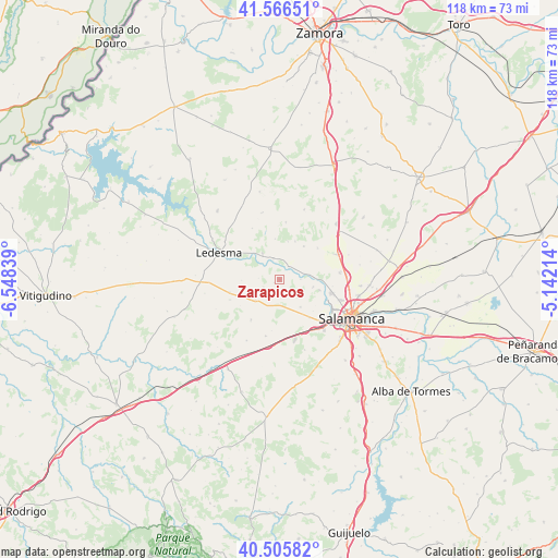
Zarapicos GPS coordinates[2]
41° 2' 17.88" North, 5° 50' 42.936" West
| Map corner | latitude | longitude |
|---|---|---|
| Upper-left | 41.56651°, | -6.54839° |
| Center: | 41.0383°, | -5.84526° |
| Lower-right: | 40.50582°, | -5.14214° |
| Map W x H: | 117.9×117.9 km | = 73.3×73.3mi |
| max Lat: | 43.74134° ⇑50.6% North |
| Zarapicos: | 41.0383° |
| min Lat: | ⇓49.4% South 27.64134° |
| min Long | Zarapicos | max Long |
| -18.00367° | -5.84526° | 4.2899° |
| W 16.2%⇐ | ⇒83.8% E |
Elevation
Elevation of Zarapicos is 784 m = 2572 ft, and this is 186 m = 610 ft above average elevation for this country.
| Max E: |
1682 m = 5518 ft | 34.1% |
| Zarapicos | 784 m 2572 ft | |
| Avg. | 598 m = 1962 ft | |
Min E: |
0 m = 0 ft | 65.9% |
See also: Spain elevation on elevation.city.
Geographical zone
Zarapicos is located in North temperate zone (between Tropic of Cancer and the Arctic Circle). Distance of this Northern Tropic circle is 1957.1 km =1216.1 mi to South.| Distance of | km | miles | from Zarapicos |
|---|---|---|---|
| North Pole | 5444 | 3382.7 | to North |
| Arctic Circle | 2838.1 | 1763.5 | to North |
| Tropic Cancer | 1957.1 | 1216.1 | to South |
| Equator | 4563 | 2835.3 | to South |


Nearby cities:
15 places around Zarapicos: (largest is in red/bold)
• Aldearrodrigo
8.5 km =5.3 mi,  21°
21°
• Almenara de Tormes
3.4 km =2.1 mi,  32°
32°
• Carrascal de Barregas
9.6 km =6 mi,  133°
133°
• Florida de Liébana
7.1 km =4.4 mi,  103°
103°
• Forfoleda
10.4 km =6.5 mi,  50°
50°
• Galindo y Perahuy
10.8 km =6.7 mi,  192°
192°
• Golpejas
6.7 km =4.2 mi,  230°
230°
• Juzbado
4.6 km =2.9 mi,  342°
342°
• Parada de Arriba
7.2 km =4.5 mi,  142°
142°
• Rollán
10.4 km =6.5 mi,  215°
215°
• San Pedro del Valle
1.4 km =0.9 mi,  246°
246°
• San Pelayo de Guareña
8.7 km =5.4 mi,  353°
353°
• Torresmenudas
8.8 km =5.5 mi,  35°
35°
• Valverdón
6.4 km =4 mi,  81°
81°
• Vega de Tirados
3.8 km =2.4 mi, 247°
Sources, notices
• [Note1] Compared only with cities in Spain existing in our database
• [Src1] Map data: © OpenStreetMap contributors (CC-BY-SA)
• [Src2] Other city data from geonames.org with taken over terms of usage.
• [Src3] Geographical zone / Annual Mean Temperature by Robert A. Rohde @ Wikipedia
