Valverdón geodata
Valverdón (Castille and León) is a seat of a third-order administrative division; located in Spain in Europe/Madrid (GMT+2) time zone. With population of 294 people, there are 4527 cities with bigger population in this country. Compared to other cities in Spain, 50.5% of cities are located further ↑North; 82.8% of cities are located further →East and 63.5% of cities have lower elevation than Valverdón. Note1
Administrative division(s):
- Level 1: Castille and León
- Level 2: Provincia de Salamanca
- Level 3: Valverdón


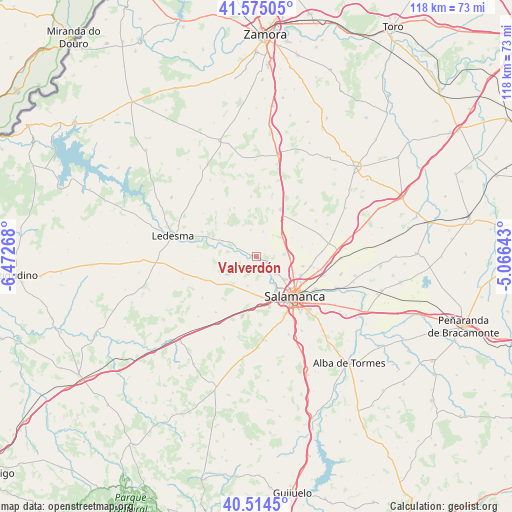
Valverdón GPS coordinates[2]
41° 2' 48.876" North, 5° 46' 10.38" West
| Map corner | latitude | longitude |
|---|---|---|
| Upper-left | 41.57505°, | -6.47268° |
| Center: | 41.04691°, | -5.76955° |
| Lower-right: | 40.5145°, | -5.06643° |
| Map W x H: | 117.9×117.9 km | = 73.3×73.3mi |
| max Lat: | 43.74134° ⇑50.5% North |
| Valverdón: | 41.04691° |
| min Lat: | ⇓49.5% South 27.64134° |
| min Long | Valverdón | max Long |
| -18.00367° | -5.76955° | 4.2899° |
| W 17.2%⇐ | ⇒82.8% E |
Elevation
Elevation of Valverdón is 767 m = 2516 ft, and this is 169 m = 554 ft above average elevation for this country.
| Max E: |
1682 m = 5518 ft | 36.5% |
| Valverdón | 767 m 2516 ft | |
| Avg. | 598 m = 1962 ft | |
Min E: |
0 m = 0 ft | 63.5% |
See also: Spain elevation on elevation.city.
Geographical zone
Valverdón is located in North temperate zone (between Tropic of Cancer and the Arctic Circle). Distance of this Northern Tropic circle is 1958.1 km =1216.7 mi to South.| Distance of | km | miles | from Valverdón |
|---|---|---|---|
| North Pole | 5443.1 | 3382.2 | to North |
| Arctic Circle | 2837.2 | 1763 | to North |
| Tropic Cancer | 1958.1 | 1216.7 | to South |
| Equator | 4564 | 2835.9 | to South |


Nearby cities:
15 places around Valverdón: (largest is in red/bold)
• Aldearrodrigo
7.7 km =4.8 mi,  335°
335°
• Almenara de Tormes
4.9 km =3 mi,  292°
292°
• Calzada de Valdunciel
7.2 km =4.5 mi,  51°
51°
• Carrascal de Barregas
7.6 km =4.7 mi,  175°
175°
• Castellanos de Villiquera
6.3 km =3.9 mi,  85°
85°
• Doñinos de Salamanca
9.9 km =6.2 mi,  167°
167°
• Florida de Liébana
2.7 km =1.7 mi, 167°
• Forfoleda
5.9 km =3.7 mi,  16°
16°
• Juzbado
8.4 km =5.2 mi, 294°
• Parada de Arriba
7 km =4.3 mi,  196°
196°
• San Pedro del Valle
7.8 km =4.8 mi,  258°
258°
• Torresmenudas
6.3 km =3.9 mi,  348°
348°
• Valdunciel
9.2 km =5.7 mi,  62°
62°
• Villamayor
8.1 km =5 mi,  130°
130°
• Zarapicos
6.4 km =4 mi, 261°
Sources, notices
• [Note1] Compared only with cities in Spain existing in our database
• [Src1] Map data: © OpenStreetMap contributors (CC-BY-SA)
• [Src2] Other city data from geonames.org with taken over terms of usage.
• [Src3] Geographical zone / Annual Mean Temperature by Robert A. Rohde @ Wikipedia
