Rollán geodata
Rollán (Castille and León) is a seat of a third-order administrative division; located in Spain in Europe/Madrid (GMT+2) time zone. With population of 538 people, there are 3766 cities with bigger population in this country. Compared to other cities in Spain, 52.5% of cities are located further ↑North; 84.9% of cities are located further →East and 68% of cities have lower elevation than Rollán. Note1
Administrative division(s):
- Level 1: Castille and León
- Level 2: Provincia de Salamanca
- Level 3: Rollán


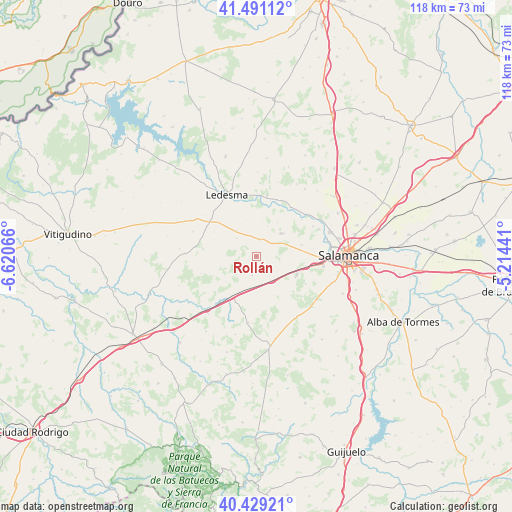
Rollán GPS coordinates[2]
40° 57' 44.28" North, 5° 55' 3.108" West
| Map corner | latitude | longitude |
|---|---|---|
| Upper-left | 41.49112°, | -6.62066° |
| Center: | 40.9623°, | -5.91753° |
| Lower-right: | 40.42921°, | -5.21441° |
| Map W x H: | 118.1×118.1 km | = 73.4×73.4mi |
| max Lat: | 43.74134° ⇑52.5% North |
| Rollán: | 40.9623° |
| min Lat: | ⇓47.5% South 27.64134° |
| min Long | Rollán | max Long |
| -18.00367° | -5.91753° | 4.2899° |
| W 15.1%⇐ | ⇒84.9% E |
Elevation
Elevation of Rollán is 799 m = 2621 ft, and this is 201 m = 659 ft above average elevation for this country.
| Max E: |
1682 m = 5518 ft | 32% |
| Rollán | 799 m 2621 ft | |
| Avg. | 598 m = 1962 ft | |
Min E: |
0 m = 0 ft | 68% |
See also: Spain elevation on elevation.city.
Geographical zone
Rollán is located in North temperate zone (between Tropic of Cancer and the Arctic Circle). Distance of this Northern Tropic circle is 1948.7 km =1210.9 mi to South.| Distance of | km | miles | from Rollán |
|---|---|---|---|
| North Pole | 5452.5 | 3388 | to North |
| Arctic Circle | 2846.6 | 1768.8 | to North |
| Tropic Cancer | 1948.7 | 1210.9 | to South |
| Equator | 4554.6 | 2830.1 | to South |


Nearby cities:
15 places around Rollán: (largest is in red/bold)
• Almenara de Tormes
13.8 km =8.6 mi,  34°
34°
• Calzada de Don Diego
6.5 km =4 mi,  169°
169°
• Canillas de Abajo
4.5 km =2.8 mi,  192°
192°
• Carrascal de Barregas
13.2 km =8.2 mi,  82°
82°
• Doñinos de Ledesma
11.3 km =7 mi,  299°
299°
• Galindo y Perahuy
4.2 km =2.6 mi,  119°
119°
• Golpejas
4.3 km =2.7 mi,  12°
12°
• Juzbado
13.7 km =8.5 mi,  20°
20°
• Parada de Arriba
10.8 km =6.7 mi, 75°
• Robliza de Cojos
11.7 km =7.3 mi,  205°
205°
• San Pedro del Valle
9.2 km =5.7 mi, 31°
• Tabera de Abajo
9.2 km =5.7 mi,  230°
230°
• Vega de Tirados
7.5 km =4.7 mi, 20°
• Villarmayor
7.4 km =4.6 mi,  322°
322°
• Zarapicos
10.4 km =6.5 mi,  35°
35°
Sources, notices
• [Note1] Compared only with cities in Spain existing in our database
• [Src1] Map data: © OpenStreetMap contributors (CC-BY-SA)
• [Src2] Other city data from geonames.org with taken over terms of usage.
• [Src3] Geographical zone / Annual Mean Temperature by Robert A. Rohde @ Wikipedia
