Zaidín geodata
Zaidín (Aragon) is a populated place; located in Spain in Europe/Madrid (GMT+2) time zone. With population of 1,721 people, there are 2326 cities with bigger population in this country. Compared to other cities in Spain, 63.6% of cities are located further ↓South; 88.2% of cities are located further ←West and 83.5% of cities have higher elevation than Zaidín. Note1


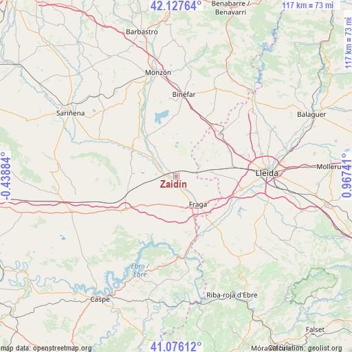
Zaidín GPS coordinates[2]
41° 36' 14.472" North, 0° 15' 51.444" East
| Map corner | latitude | longitude |
|---|---|---|
| Upper-left | 42.12764°, | -0.43884° |
| Center: | 41.60402°, | 0.26429° |
| Lower-right: | 41.07612°, | 0.96741° |
| Map W x H: | 116.9×116.9 km | = 72.6×72.6mi |
| max Lat: | 43.74134° ⇑36.4% North |
| Zaidín: | 41.60402° |
| min Lat: | ⇓63.6% South 27.64134° |
| min Long | Zaidín | max Long |
| -18.00367° | 0.26429° | 4.2899° |
| W 88.2%⇐ | ⇒11.8% E |
Elevation
Elevation of Zaidín is 162 m = 531 ft, and this is 436 m = 1430 ft below average elevation for this country.
| Max E: |
1682 m = 5518 ft | 83.5% |
| Avg. | 598 m = 1962 ft | |
| Zaidín | 162 m = 531 ft | |
Min E: |
0 m = 0 ft | 16.5% |
See also: Spain elevation on elevation.city.
Geographical zone
Zaidín is located in North temperate zone (between Tropic of Cancer and the Arctic Circle). Distance of this Northern Tropic circle is 2020 km =1255.2 mi to South.| Distance of | km | miles | from Zaidín |
|---|---|---|---|
| North Pole | 5381.1 | 3343.7 | to North |
| Arctic Circle | 2775.2 | 1724.4 | to North |
| Tropic Cancer | 2020 | 1255.2 | to South |
| Equator | 4625.9 | 2874.4 | to South |


Nearby cities:
15 places around Zaidín: (largest is in red/bold)
• Aitona
21.5 km =13.4 mi,  128°
128°
• Albalate de Cinca
16.4 km =10.2 mi,  325°
325°
• Alcarràs
21.4 km =13.3 mi,  101°
101°
• Alcolea de Cinca
17.7 km =11 mi,  316°
316°
• Almacelles
20.2 km =12.6 mi,  45°
45°
• Ballobar
6.3 km =3.9 mi,  287°
287°
• Belver de Cinca
12.2 km =7.6 mi, 324°
• Candasnos
20.1 km =12.5 mi,  235°
235°
• Chalamera
10.9 km =6.8 mi,  309°
309°
• Fraga
11.4 km =7.1 mi,  142°
142°
• Ontiñena
16.7 km =10.4 mi,  298°
298°
• Osso de Cinca
9.2 km =5.7 mi, 318°
• Seròs
19.9 km =12.4 mi, 140°
• Soses
19.8 km =12.3 mi,  113°
113°
• Torrent de Cinca / Torrente de Cinca
15.7 km =9.8 mi,  157°
157°
Sources, notices
• [Note1] Compared only with cities in Spain existing in our database
• [Src1] Map data: © OpenStreetMap contributors (CC-BY-SA)
• [Src2] Other city data from geonames.org with taken over terms of usage.
• [Src3] Geographical zone / Annual Mean Temperature by Robert A. Rohde @ Wikipedia
