Fraga geodata
Fraga (Aragon) is a seat of a third-order administrative division; located in Spain in Europe/Madrid (GMT+2) time zone. With population of 14,302 people, there are 644 cities with bigger population in this country. Compared to other cities in Spain, 61.3% of cities are located further ↓South; 88.5% of cities are located further ←West and 85.3% of cities have higher elevation than Fraga. Note1


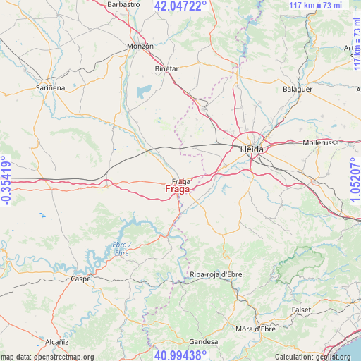
Fraga GPS coordinates[2]
41° 31' 22.584" North, 0° 20' 56.184" East
| Map corner | latitude | longitude |
|---|---|---|
| Upper-left | 42.04722°, | -0.35419° |
| Center: | 41.52294°, | 0.34894° |
| Lower-right: | 40.99438°, | 1.05207° |
| Map W x H: | 117.1×117.1 km | = 72.8×72.8mi |
| max Lat: | 43.74134° ⇑38.7% North |
| Fraga: | 41.52294° |
| min Lat: | ⇓61.3% South 27.64134° |
| min Long | Fraga | max Long |
| -18.00367° | 0.34894° | 4.2899° |
| W 88.5%⇐ | ⇒11.5% E |
Elevation
Elevation of Fraga is 134 m = 440 ft, and this is 464 m = 1522 ft below average elevation for this country.
| Max E: |
1682 m = 5518 ft | 85.3% |
| Avg. | 598 m = 1962 ft | |
| Fraga | 134 m = 440 ft | |
Min E: |
0 m = 0 ft | 14.7% |
See also: Spain elevation on elevation.city.
Geographical zone
Fraga is located in North temperate zone (between Tropic of Cancer and the Arctic Circle). Distance of this Northern Tropic circle is 2011 km =1249.6 mi to South.| Distance of | km | miles | from Fraga |
|---|---|---|---|
| North Pole | 5390.1 | 3349.3 | to North |
| Arctic Circle | 2784.3 | 1730.1 | to North |
| Tropic Cancer | 2011 | 1249.6 | to South |
| Equator | 4616.9 | 2868.8 | to South |


Nearby cities:
15 places around Fraga: (largest is in red/bold)
• Aitona
10.7 km =6.6 mi,  114°
114°
• Alcarràs
14.8 km =9.2 mi,  70°
70°
• Ballobar
17 km =10.6 mi,  309°
309°
• Chalamera
22.2 km =13.8 mi,  315°
315°
• Maials
21.5 km =13.4 mi,  144°
144°
• Mequinensa / Mequinenza
17.2 km =10.7 mi,  193°
193°
• Osso de Cinca
20.6 km =12.8 mi, 320°
• Seròs
8.4 km =5.2 mi, 137°
• Soses
11.2 km =7 mi,  84°
84°
• Sudanell
18.5 km =11.5 mi, 78°
• Sunyer
20.2 km =12.6 mi,  90°
90°
• Torrent de Cinca / Torrente de Cinca
5.6 km =3.5 mi, 191°
• Torres de Segre
13.8 km =8.6 mi, 84°
• Zaidín
11.4 km =7.1 mi, 322°
• la Granja d'Escarp
11.9 km =7.4 mi,  172°
172°
Sources, notices
• [Note1] Compared only with cities in Spain existing in our database
• [Src1] Map data: © OpenStreetMap contributors (CC-BY-SA)
• [Src2] Other city data from geonames.org with taken over terms of usage.
• [Src3] Geographical zone / Annual Mean Temperature by Robert A. Rohde @ Wikipedia
