Alcarràs geodata
Alcarràs (Catalonia) is a seat of a third-order administrative division; located in Spain in Europe/Madrid (GMT+1) time zone. With population of 5,133 people, there are 1275 cities with bigger population in this country. Compared to other cities in Spain, 62.5% of cities are located further ↓South; 89% of cities are located further ←West and 85.6% of cities have higher elevation than Alcarràs. Note1


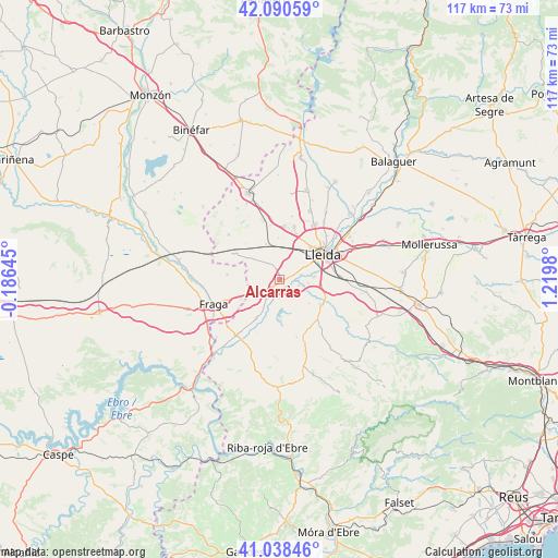
Alcarràs GPS coordinates[2]
41° 34' 0.012" North, 0° 31' 0.012" East
| Map corner | latitude | longitude |
|---|---|---|
| Upper-left | 42.09059°, | -0.18645° |
| Center: | 41.56667°, | 0.51667° |
| Lower-right: | 41.03846°, | 1.2198° |
| Map W x H: | 117×117 km | = 72.7×72.7mi |
| max Lat: | 43.74134° ⇑37.5% North |
| Alcarràs: | 41.56667° |
| min Lat: | ⇓62.5% South 27.64134° |
| min Long | Alcarràs | max Long |
| -18.00367° | 0.51667° | 4.2899° |
| W 89%⇐ | ⇒11% E |
Elevation
Elevation of Alcarràs is 130 m = 427 ft, and this is 468 m = 1535 ft below average elevation for this country.
| Max E: |
1682 m = 5518 ft | 85.6% |
| Avg. | 598 m = 1962 ft | |
| Alcarràs | 130 m = 427 ft | |
Min E: |
0 m = 0 ft | 14.4% |
See also: Spain elevation on elevation.city.
Geographical zone
Alcarràs is located in North temperate zone (between Tropic of Cancer and the Arctic Circle). Distance of this Northern Tropic circle is 2015.9 km =1252.6 mi to South.| Distance of | km | miles | from Alcarràs |
|---|---|---|---|
| North Pole | 5385.3 | 3346.3 | to North |
| Arctic Circle | 2779.4 | 1727 | to North |
| Tropic Cancer | 2015.9 | 1252.6 | to South |
| Equator | 4621.8 | 2871.9 | to South |


Nearby cities:
15 places around Alcarràs: (largest is in red/bold)
• Aitona
10.2 km =6.3 mi,  204°
204°
• Alcanó
12.7 km =7.9 mi,  138°
138°
• Alcoletge
17.3 km =10.7 mi,  58°
58°
• Alfés
10 km =6.2 mi,  120°
120°
• Alpicat
11.5 km =7.1 mi,  16°
16°
• Aspa
15.3 km =9.5 mi, 121°
• Fraga
14.8 km =9.2 mi,  250°
250°
• Lleida
10.4 km =6.5 mi, 57°
• Seròs
13.9 km =8.6 mi,  216°
216°
• Soses
4.6 km =2.9 mi, 216°
• Sudanell
4.3 km =2.7 mi,  104°
104°
• Sunyer
7.9 km =4.9 mi,  127°
127°
• Torrebesses
16.4 km =10.2 mi,  154°
154°
• Torrefarrera
14 km =8.7 mi,  32°
32°
• Torres de Segre
3.6 km =2.2 mi,  183°
183°
Sources, notices
• [Note1] Compared only with cities in Spain existing in our database
• [Src1] Map data: © OpenStreetMap contributors (CC-BY-SA)
• [Src2] Other city data from geonames.org with taken over terms of usage.
• [Src3] Geographical zone / Annual Mean Temperature by Robert A. Rohde @ Wikipedia
