Ballobar geodata
Ballobar (Aragon) is a seat of a third-order administrative division; located in Spain in Europe/Madrid (GMT+2) time zone. With population of 1,021 people, there are 2909 cities with bigger population in this country. Compared to other cities in Spain, 64% of cities are located further ↓South; 87.9% of cities are located further ←West and 84.3% of cities have higher elevation than Ballobar. Note1


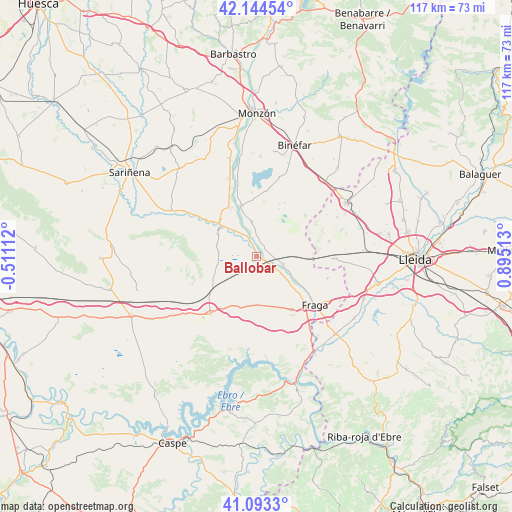
Ballobar GPS coordinates[2]
41° 37' 15.816" North, 0° 11' 31.2" East
| Map corner | latitude | longitude |
|---|---|---|
| Upper-left | 42.14454°, | -0.51112° |
| Center: | 41.62106°, | 0.192° |
| Lower-right: | 41.0933°, | 0.89513° |
| Map W x H: | 116.9×116.9 km | = 72.6×72.6mi |
| max Lat: | 43.74134° ⇑36% North |
| Ballobar: | 41.62106° |
| min Lat: | ⇓64% South 27.64134° |
| min Long | Ballobar | max Long |
| -18.00367° | 0.192° | 4.2899° |
| W 87.9%⇐ | ⇒12.1% E |
Elevation
Elevation of Ballobar is 152 m = 499 ft, and this is 446 m = 1463 ft below average elevation for this country.
| Max E: |
1682 m = 5518 ft | 84.3% |
| Avg. | 598 m = 1962 ft | |
| Ballobar | 152 m = 499 ft | |
Min E: |
0 m = 0 ft | 15.7% |
See also: Spain elevation on elevation.city.
Geographical zone
Ballobar is located in North temperate zone (between Tropic of Cancer and the Arctic Circle). Distance of this Northern Tropic circle is 2021.9 km =1256.4 mi to South.| Distance of | km | miles | from Ballobar |
|---|---|---|---|
| North Pole | 5379.2 | 3342.5 | to North |
| Arctic Circle | 2773.3 | 1723.2 | to North |
| Tropic Cancer | 2021.9 | 1256.4 | to South |
| Equator | 4627.8 | 2875.6 | to South |


Nearby cities:
15 places around Ballobar: (largest is in red/bold)
• Albalate de Cinca
12 km =7.5 mi,  344°
344°
• Alcolea de Cinca
12.6 km =7.8 mi,  330°
330°
• Belver de Cinca
8 km =5 mi,  351°
351°
• Binaced
22.8 km =14.2 mi,  1°
1°
• Candasnos
17 km =10.6 mi,  218°
218°
• Chalamera
5.5 km =3.4 mi, 334°
• Esplús
20.9 km =13 mi,  19°
19°
• Fraga
17 km =10.6 mi,  129°
129°
• Ontiñena
10.6 km =6.6 mi,  305°
305°
• Osso de Cinca
5 km =3.1 mi,  359°
359°
• Peñalba
23.3 km =14.5 mi,  235°
235°
• Sena
22.1 km =13.7 mi,  298°
298°
• Torrent de Cinca / Torrente de Cinca
20.3 km =12.6 mi,  143°
143°
• Villanueva de Sigena
19.7 km =12.2 mi, 302°
• Zaidín
6.3 km =3.9 mi,  107°
107°
Sources, notices
• [Note1] Compared only with cities in Spain existing in our database
• [Src1] Map data: © OpenStreetMap contributors (CC-BY-SA)
• [Src2] Other city data from geonames.org with taken over terms of usage.
• [Src3] Geographical zone / Annual Mean Temperature by Robert A. Rohde @ Wikipedia
