Villasdardo geodata
Villasdardo (Castille and León) is a seat of a third-order administrative division; located in Spain in Europe/Madrid (GMT+2) time zone. With population of 18 people, there are 6737 cities with bigger population in this country. Compared to other cities in Spain, 51.4% of cities are located further ↑North; 88.1% of cities are located further →East and 69.7% of cities have lower elevation than Villasdardo. Note1
Administrative division(s):
- Level 1: Castille and León
- Level 2: Provincia de Salamanca
- Level 3: Villasdardo


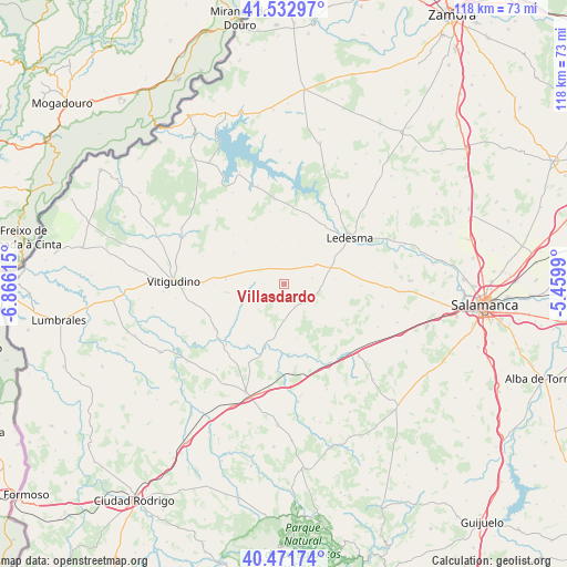
Villasdardo GPS coordinates[2]
41° 0' 16.164" North, 6° 9' 46.908" West
| Map corner | latitude | longitude |
|---|---|---|
| Upper-left | 41.53297°, | -6.86615° |
| Center: | 41.00449°, | -6.16303° |
| Lower-right: | 40.47174°, | -5.4599° |
| Map W x H: | 118×118 km | = 73.3×73.3mi |
| max Lat: | 43.74134° ⇑51.4% North |
| Villasdardo: | 41.00449° |
| min Lat: | ⇓48.6% South 27.64134° |
| min Long | Villasdardo | max Long |
| -18.00367° | -6.16303° | 4.2899° |
| W 11.9%⇐ | ⇒88.1% E |
Elevation
Elevation of Villasdardo is 812 m = 2664 ft, and this is 214 m = 702 ft above average elevation for this country.
| Max E: |
1682 m = 5518 ft | 30.3% |
| Villasdardo | 812 m 2664 ft | |
| Avg. | 598 m = 1962 ft | |
Min E: |
0 m = 0 ft | 69.7% |
See also: Spain elevation on elevation.city.
Geographical zone
Villasdardo is located in North temperate zone (between Tropic of Cancer and the Arctic Circle). Distance of this Northern Tropic circle is 1953.4 km =1213.8 mi to South.| Distance of | km | miles | from Villasdardo |
|---|---|---|---|
| North Pole | 5447.8 | 3385.1 | to North |
| Arctic Circle | 2841.9 | 1765.9 | to North |
| Tropic Cancer | 1953.4 | 1213.8 | to South |
| Equator | 4559.3 | 2833 | to South |


Nearby cities:
15 places around Villasdardo: (largest is in red/bold)
• Cipérez
9.8 km =6.1 mi,  241°
241°
• Doñinos de Ledesma
10.9 km =6.8 mi,  85°
85°
• Encina de San Silvestre
6 km =3.7 mi,  79°
79°
• Espadaña
12 km =7.5 mi,  301°
301°
• Garcirrey
11.9 km =7.4 mi,  166°
166°
• Gejuelo del Barro
8.7 km =5.4 mi,  22°
22°
• Pelarrodríguez
13.7 km =8.5 mi,  197°
197°
• Peralejos de Arriba
14.3 km =8.9 mi,  269°
269°
• Puertas
14.6 km =9.1 mi,  314°
314°
• Sando
6 km =3.7 mi,  133°
133°
• Santa María de Sando
4 km =2.5 mi, 134°
• Tremedal de Tormes
7.9 km =4.9 mi,  348°
348°
• Villar de Peralonso
5.9 km =3.7 mi, 301°
• Villarmayor
16.1 km =10 mi, 85°
• Villaseco de los Gamitos
5.5 km =3.4 mi,  49°
49°
Sources, notices
• [Note1] Compared only with cities in Spain existing in our database
• [Src1] Map data: © OpenStreetMap contributors (CC-BY-SA)
• [Src2] Other city data from geonames.org with taken over terms of usage.
• [Src3] Geographical zone / Annual Mean Temperature by Robert A. Rohde @ Wikipedia
