Sando geodata
Sando (Castille and León) is a seat of a third-order administrative division; located in Spain in Europe/Madrid (GMT+2) time zone. With population of 240 people, there are 4806 cities with bigger population in this country. Compared to other cities in Spain, 52.4% of cities are located further ↑North; 87.5% of cities are located further →East and 73.5% of cities have lower elevation than Sando. Note1
Administrative division(s):
- Level 1: Castille and León
- Level 2: Provincia de Salamanca
- Level 3: Sando


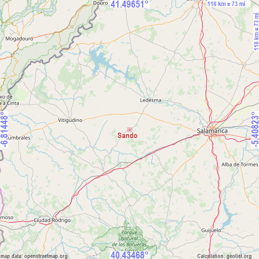
Sando GPS coordinates[2]
40° 58' 3.828" North, 6° 6' 40.896" West
| Map corner | latitude | longitude |
|---|---|---|
| Upper-left | 41.49651°, | -6.81448° |
| Center: | 40.96773°, | -6.11136° |
| Lower-right: | 40.43468°, | -5.40823° |
| Map W x H: | 118.1×118.1 km | = 73.4×73.4mi |
| max Lat: | 43.74134° ⇑52.4% North |
| Sando: | 40.96773° |
| min Lat: | ⇓47.6% South 27.64134° |
| min Long | Sando | max Long |
| -18.00367° | -6.11136° | 4.2899° |
| W 12.5%⇐ | ⇒87.5% E |
Elevation
Elevation of Sando is 839 m = 2753 ft, and this is 241 m = 791 ft above average elevation for this country.
| Max E: |
1682 m = 5518 ft | 26.5% |
| Sando | 839 m 2753 ft | |
| Avg. | 598 m = 1962 ft | |
Min E: |
0 m = 0 ft | 73.5% |
See also: Spain elevation on elevation.city.
Geographical zone
Sando is located in North temperate zone (between Tropic of Cancer and the Arctic Circle). Distance of this Northern Tropic circle is 1949.3 km =1211.2 mi to South.| Distance of | km | miles | from Sando |
|---|---|---|---|
| North Pole | 5451.9 | 3387.7 | to North |
| Arctic Circle | 2846 | 1768.4 | to North |
| Tropic Cancer | 1949.3 | 1211.2 | to South |
| Equator | 4555.2 | 2830.5 | to South |


Nearby cities:
15 places around Sando: (largest is in red/bold)
• Aldehuela de la Bóveda
13.9 km =8.6 mi,  159°
159°
• Cipérez
13 km =8.1 mi,  267°
267°
• Doñinos de Ledesma
8.2 km =5.1 mi,  52°
52°
• Encina de San Silvestre
5.4 km =3.4 mi,  16°
16°
• Garcirrey
7.7 km =4.8 mi,  192°
192°
• Gejuelo del Barro
12.1 km =7.5 mi,  355°
355°
• Pelarrodríguez
12.4 km =7.7 mi,  223°
223°
• Robliza de Cojos
15.8 km =9.8 mi,  134°
134°
• Santa María de Sando
1.9 km =1.2 mi,  310°
310°
• Tabera de Abajo
11.2 km =7 mi,  124°
124°
• Tremedal de Tormes
13.2 km =8.2 mi,  333°
333°
• Villar de Peralonso
11.8 km =7.3 mi, 307°
• Villarmayor
12.9 km =8 mi,  65°
65°
• Villasdardo
6 km =3.7 mi, 313°
• Villaseco de los Gamitos
7.6 km =4.7 mi, 358°
Sources, notices
• [Note1] Compared only with cities in Spain existing in our database
• [Src1] Map data: © OpenStreetMap contributors (CC-BY-SA)
• [Src2] Other city data from geonames.org with taken over terms of usage.
• [Src3] Geographical zone / Annual Mean Temperature by Robert A. Rohde @ Wikipedia
