Tremedal de Tormes geodata
Tremedal de Tormes (Castille and León) is a seat of a third-order administrative division; located in Spain in Europe/Madrid (GMT+2) time zone. With population of 36 people, there are 6610 cities with bigger population in this country. Compared to other cities in Spain, 50.3% of cities are located further ↓South; 88.3% of cities are located further →East and 64% of cities have lower elevation than Tremedal de Tormes. Note1
Administrative division(s):
- Level 1: Castille and León
- Level 2: Provincia de Salamanca
- Level 3: Tremedal de Tormes


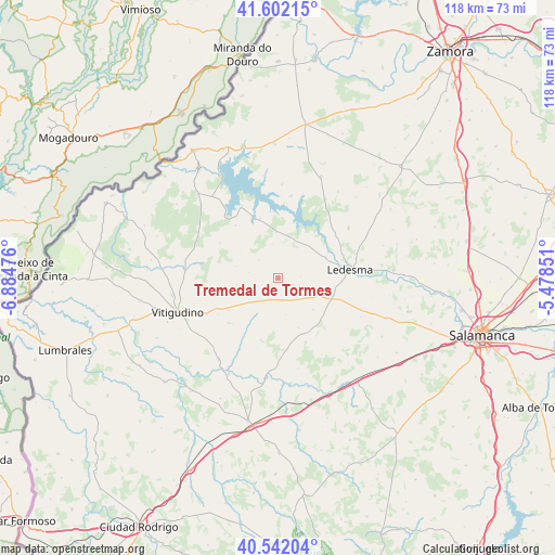
Tremedal de Tormes GPS coordinates[2]
41° 4' 27.228" North, 6° 10' 53.904" West
| Map corner | latitude | longitude |
|---|---|---|
| Upper-left | 41.60215°, | -6.88476° |
| Center: | 41.07423°, | -6.18164° |
| Lower-right: | 40.54204°, | -5.47851° |
| Map W x H: | 117.9×117.9 km | = 73.3×73.3mi |
| max Lat: | 43.74134° ⇑49.7% North |
| Tremedal de Tormes: | 41.07423° |
| min Lat: | ⇓50.3% South 27.64134° |
| min Long | Tremedal de Tor | max Long |
| -18.00367° | -6.18164° | 4.2899° |
| W 11.7%⇐ | ⇒88.3% E |
Elevation
Elevation of Tremedal de Tormes is 771 m = 2530 ft, and this is 173 m = 568 ft above average elevation for this country.
| Max E: |
1682 m = 5518 ft | 36% |
| Tremedal de Tormes | 771 m 2530 ft | |
| Avg. | 598 m = 1962 ft | |
Min E: |
0 m = 0 ft | 64% |
See also: Spain elevation on elevation.city.
Geographical zone
Tremedal de Tormes is located in North temperate zone (between Tropic of Cancer and the Arctic Circle). Distance of this Northern Tropic circle is 1961.1 km =1218.6 mi to South.| Distance of | km | miles | from Tremedal de Tormes |
|---|---|---|---|
| North Pole | 5440 | 3380.3 | to North |
| Arctic Circle | 2834.1 | 1761 | to North |
| Tropic Cancer | 1961.1 | 1218.6 | to South |
| Equator | 4567 | 2837.8 | to South |


Nearby cities:
15 places around Tremedal de Tormes: (largest is in red/bold)
• Brincones
14.7 km =9.1 mi,  287°
287°
• Cipérez
14.3 km =8.9 mi,  209°
209°
• Doñinos de Ledesma
14.1 km =8.8 mi,  119°
119°
• Encina de San Silvestre
10 km =6.2 mi,  131°
131°
• Espadaña
8.8 km =5.5 mi,  260°
260°
• Gejuelo del Barro
4.9 km =3 mi,  87°
87°
• Iruelos
14.4 km =8.9 mi,  301°
301°
• Monleras
13.1 km =8.1 mi,  343°
343°
• Puertas
9.2 km =5.7 mi, 285°
• Sando
13.2 km =8.2 mi,  153°
153°
• Santa María de Sando
11.5 km =7.1 mi,  157°
157°
• Villar de Peralonso
5.8 km =3.6 mi,  216°
216°
• Villasdardo
7.9 km =4.9 mi,  168°
168°
• Villaseco de los Gamitos
7.1 km =4.4 mi, 126°
• Villaseco de los Reyes
9.8 km =6.1 mi,  358°
358°
Sources, notices
• [Note1] Compared only with cities in Spain existing in our database
• [Src1] Map data: © OpenStreetMap contributors (CC-BY-SA)
• [Src2] Other city data from geonames.org with taken over terms of usage.
• [Src3] Geographical zone / Annual Mean Temperature by Robert A. Rohde @ Wikipedia
