Villarmayor geodata
Villarmayor (Castille and León) is a seat of a third-order administrative division; located in Spain in Europe/Madrid (GMT+2) time zone. With population of 212 people, there are 4965 cities with bigger population in this country. Compared to other cities in Spain, 51.2% of cities are located further ↑North; 85.6% of cities are located further →East and 72.1% of cities have lower elevation than Villarmayor. Note1
Administrative division(s):
- Level 1: Castille and León
- Level 2: Provincia de Salamanca
- Level 3: Villarmayor


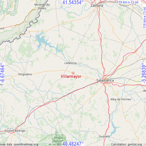
Villarmayor GPS coordinates[2]
41° 0' 54.504" North, 5° 58' 17.436" West
| Map corner | latitude | longitude |
|---|---|---|
| Upper-left | 41.54354°, | -6.67464° |
| Center: | 41.01514°, | -5.97151° |
| Lower-right: | 40.48247°, | -5.26839° |
| Map W x H: | 118×118 km | = 73.3×73.3mi |
| max Lat: | 43.74134° ⇑51.2% North |
| Villarmayor: | 41.01514° |
| min Lat: | ⇓48.8% South 27.64134° |
| min Long | Villarmayor | max Long |
| -18.00367° | -5.97151° | 4.2899° |
| W 14.4%⇐ | ⇒85.6% E |
Elevation
Elevation of Villarmayor is 828 m = 2717 ft, and this is 230 m = 755 ft above average elevation for this country.
| Max E: |
1682 m = 5518 ft | 27.9% |
| Villarmayor | 828 m 2717 ft | |
| Avg. | 598 m = 1962 ft | |
Min E: |
0 m = 0 ft | 72.1% |
See also: Spain elevation on elevation.city.
Geographical zone
Villarmayor is located in North temperate zone (between Tropic of Cancer and the Arctic Circle). Distance of this Northern Tropic circle is 1954.5 km =1214.5 mi to South.| Distance of | km | miles | from Villarmayor |
|---|---|---|---|
| North Pole | 5446.6 | 3384.4 | to North |
| Arctic Circle | 2840.7 | 1765.1 | to North |
| Tropic Cancer | 1954.5 | 1214.5 | to South |
| Equator | 4560.5 | 2833.8 | to South |


Nearby cities:
15 places around Villarmayor: (largest is in red/bold)
• Almenara de Tormes
13.5 km =8.4 mi,  66°
66°
• Canillas de Abajo
10.9 km =6.8 mi,  160°
160°
• Doñinos de Ledesma
5.3 km =3.3 mi,  266°
266°
• Encina de San Silvestre
10.2 km =6.3 mi, 269°
• Galindo y Perahuy
11.4 km =7.1 mi,  134°
134°
• Golpejas
5.7 km =3.5 mi,  107°
107°
• Juzbado
11.6 km =7.2 mi,  52°
52°
• Ledesma
8.5 km =5.3 mi,  342°
342°
• Rollán
7.4 km =4.6 mi,  142°
142°
• San Pedro del Valle
9.5 km =5.9 mi,  77°
77°
• Sando
12.9 km =8 mi,  245°
245°
• Tabera de Abajo
11.9 km =7.4 mi,  192°
192°
• Vega de Tirados
7.2 km =4.5 mi, 80°
• Villaseco de los Gamitos
12.1 km =7.5 mi,  281°
281°
• Zarapicos
10.9 km =6.8 mi, 76°
Sources, notices
• [Note1] Compared only with cities in Spain existing in our database
• [Src1] Map data: © OpenStreetMap contributors (CC-BY-SA)
• [Src2] Other city data from geonames.org with taken over terms of usage.
• [Src3] Geographical zone / Annual Mean Temperature by Robert A. Rohde @ Wikipedia
